Photo Journey Through the Faroe Islands
The Faroe Islands are a part of the majestic Kingdom of Denmark and located halfway between Iceland and Scotland in the North Atlantic Ocean. Endlessly rugged and beautiful, they are a prime location for landscape photography.
The Faroe Islands are a part of the majestic Kingdom of Denmark and located halfway between Iceland and Scotland in the North Atlantic Ocean. Endlessly rugged and beautiful, they are a prime location for landscape photography. In fact, OFFBEAT is headed back next fall for our ever-popular FAR OUT FAROES workshop!
It's one of my personal favourite places to shoot. Enjoy this compilation from this wild corner of the world!

Self-portrait at Slaettaratindur. Paul Zizka Photography.
Gasadalur locals, Vágar. Photo by Paul Zizka Photography.
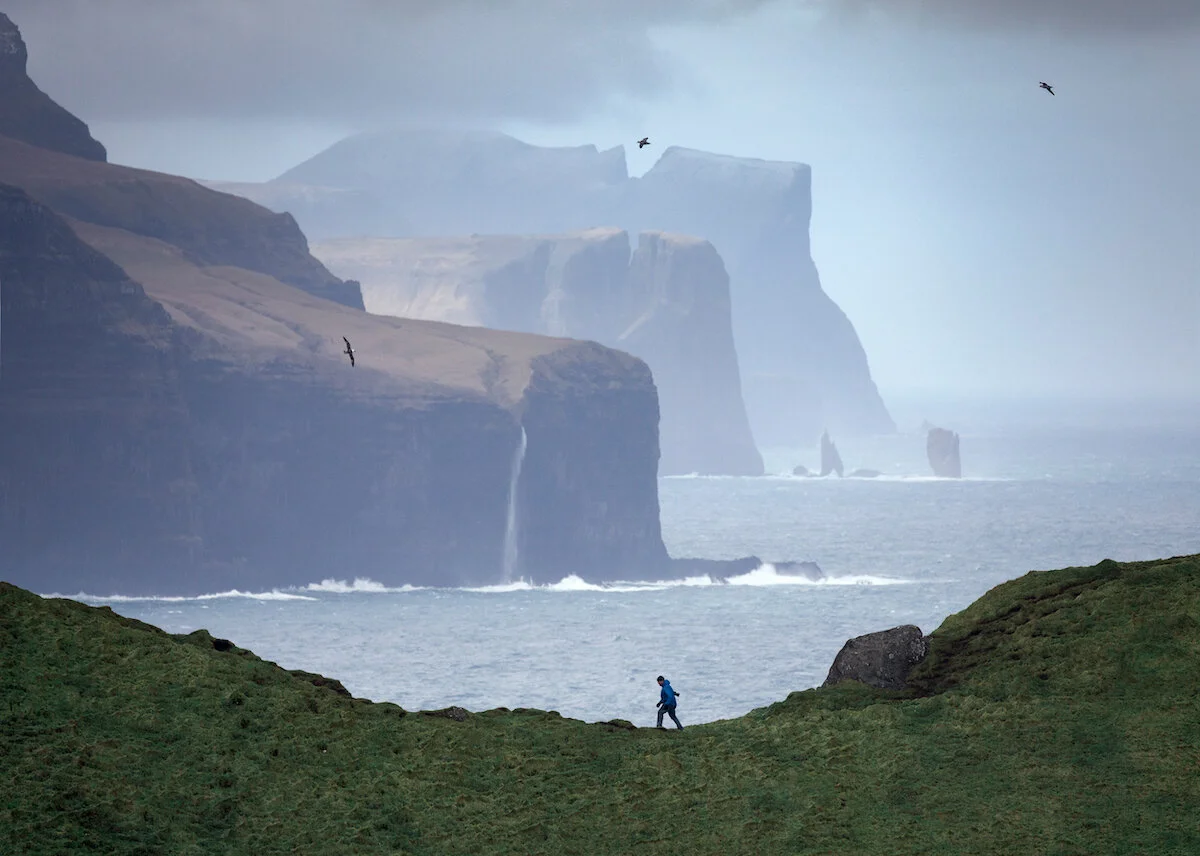
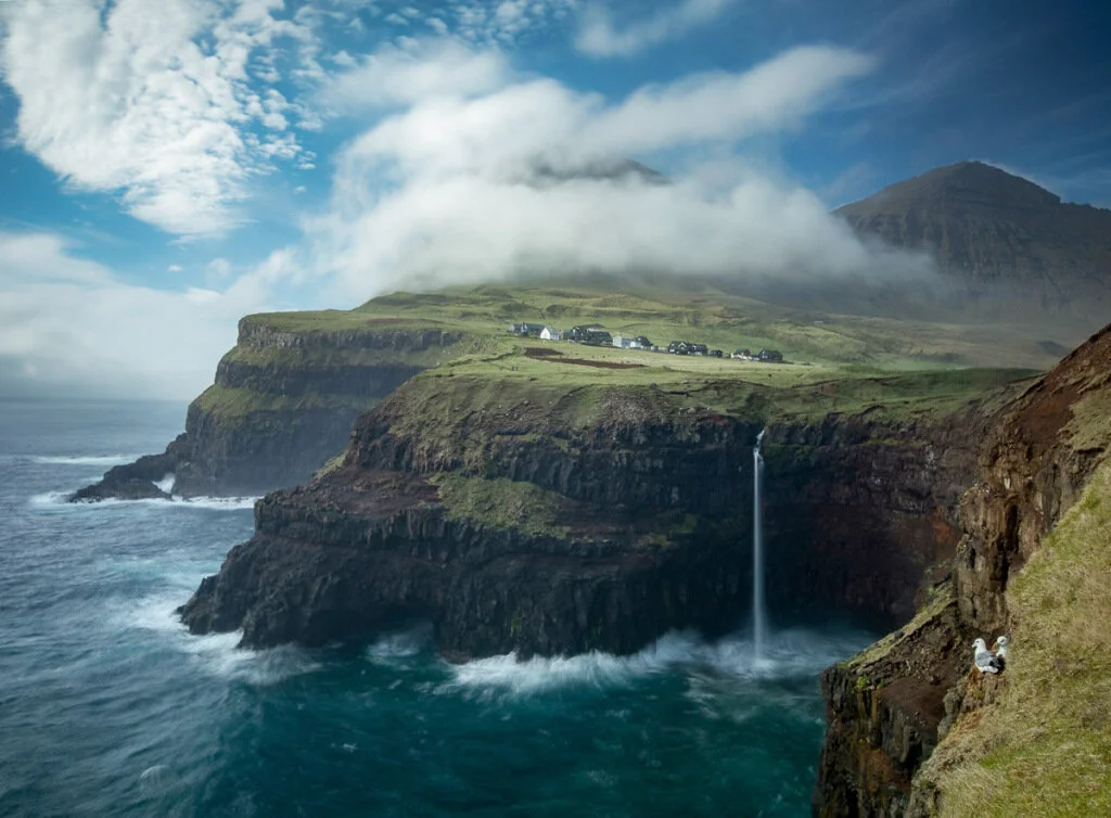
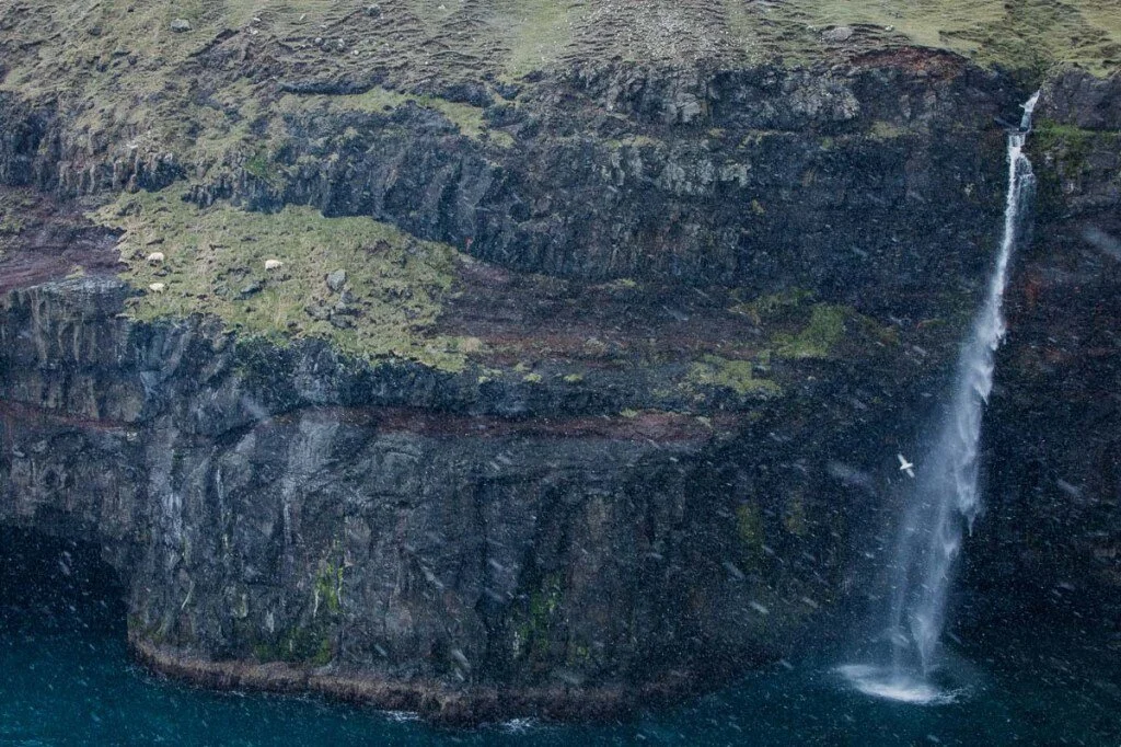
The Faroe Islands are comprised of 18 rocky islands, which are linked together via road tunnels, ferries, causeways and bridges. Many hikers, photographers, and bird-watchers are drawn to the picturesque fjords, mountains, and steep coastal cliffs that thousands of seabirds call home.


Long exposure self-portrait on a stunning day on Slaettaratindur, Eysturoy. Photo by Paul Zizka Photography.


According to the stories passed down by generations, the first known settlers were Irish monks in the sixth century. However, evidence has shown that these islands were first inhabited as far back as the year 300 AD.

Faroese paintbrush. Gjogv cliffs. Photo by Paul Zizka Photography.

The incredibly colourful seacaves of Eysturoy. Photo by Paul Zizka Photography.

Snow and sunshine atop Slaettaratindur, highest peak in the Faroe Islands.
Photo by Paul Zizka Photography.
The name Faroe Islands first appeared as Faereyjar, which translates to “Sheep Islands.” This was the name in the ninth century, given by the Viking-age settlers from Norway and presumably the reason for their national symbol: a ram.
Hardy sheep at Mulafossur, Vagar. Photo by Paul Zizka Photography.

Vestmanna cliffs, Streymoy. Photo by Paul Zizka Photography


Self-portrait, southern Vágar. Photo by Paul Zizka Photography.
This mysterious archipelago is the spot for one of our upcoming workshops with OFFBEAT Photography! Click the image below for more information or to sign up!


The Wilder Side of Malta: Gozo
I had the chance to visit Malta with my family back in December and take in its wild coastlines, dramatic rock structures, and rugged seascapes. We also toured the old city of Valletta, which was a sight to behold, but I did not take out the camera much during that portion. Naturally, I’m drawn to the sea and landscapes, and here is the best I shot while in Malta. In fact, all of these images were taken on the Maltese island of Gozo.
The Republic of Malta is a country that defies description. Its history is as multi-layered and complex as its towering cliffs that hang over the sea. Located 80 km south of Italy and 333 km north of Libya, smack in the middle of the Mediterranean, Malta has been used as a naval base for centuries. It’s culture today possesses remnants of all those that came before, from the Phoenicians and Carthaginians to Romans and Greeks, Arabs and Normans, French and British. Remarkably, the habitation of the island goes back to 5900 BC and some of the oldest man-made structures on the planet can still be found there.
I had the chance to visit Malta with my family back in December and take in its wild coastlines, dramatic rock structures, and rugged seascapes. We also toured the old city of Valletta, which was a sight to behold, but I did not take out the camera much during that portion. Naturally, I’m drawn to the sea and landscapes, and here is the best I shot while in Malta. In fact, all of these images were taken on the Maltese island of Gozo.
All of these images are available as Limited Edition Prints in a variety of sizes and formats, as well as stock image licensing.

Dwejra Bay. Photo by Paul Zizka.

Dwejra Bay. Photo by Paul Zizka.

Wied Il-Mielaħ. Photo by Paul Zizka Photography.

Xlendi Bay. Photo by Paul Zizka Photography.

Xlendi Bay. Photo by Paul Zizka Photography.

Xlendi Bay. Photo by Paul Zizka Photography.

Sanap Cliffs. Photo by Paul Zizka Photography.

The Inland Sea at Dwejra Bay. Photo by Paul Zizka Photography.

Xlendi Bay. Photo by Paul Zizka Photography.

The Inland Sea at Dwejra Bay. Photo by Paul Zizka Photography.
Behind the Image: Audience of One
This time around, play time meant finding ourselves camping on the Greenland ice sheet for three nights, about 50 kilometres away from the closest settlement, Kangerlussuaq. Our main purpose over those few days was to document supraglacial lakes, these surreal, turquoise bodies of water that have proliferated along the edge of the ice cap recently.
Earlier this month, I was fortunate to return to beautiful Greenland to lead a group with fellow photographers Stephen DesRoches and Curtis Jones. Through OFFBEAT, the company I co-founded with my friend Dave Brosha, we do a number of these epic photography trips every year. They are always rewarding journeys; it is such a privilege to be able to introduce fellow photographers to these wild corners of the planet, and to help guide them along their creative journey. Between the demands on the logistical side, and the fact that our priority is to assist participants with their own photographs, there really isn't much time for leaders to create images of their own. That's why we always make a point to add a few days to any international trip we do for pure creative time. "Play time," as we call it.
This time around, play time meant finding ourselves camping on the Greenland ice sheet for three nights, about 50 kilometres away from the closest settlement, Kangerlussuaq. Our main purpose over those few days was to document supraglacial lakes, these surreal, turquoise bodies of water that have proliferated along the edge of the ice cap recently. Unfortunately, shortly after setting foot on the ice and sending up a reconnaissance drone, we realized we were too late. Winter had arrived early in Greenland and once up on the ice, there was barely any open water to be found. We reluctantly reset our objectives, set up a base camp and focused on finding some other features to photograph. As an avid astrophotographer, my main concern during the day was locating compositions that could be recreated under the stars and, hopefully, the aurora. All of the forecasts agreed that our first two nights would be overcast, but our very last night in the area looked hopeful.
This image is available as a limited-edition print in a variety of sizes and format. See our online store for details!
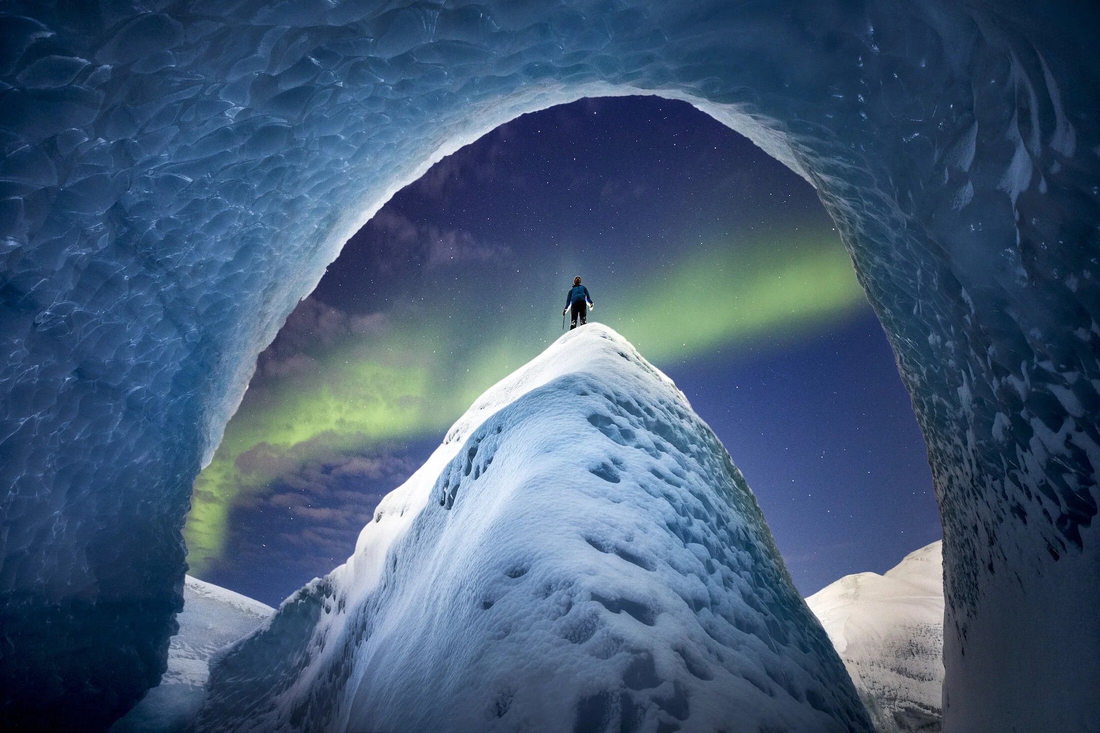
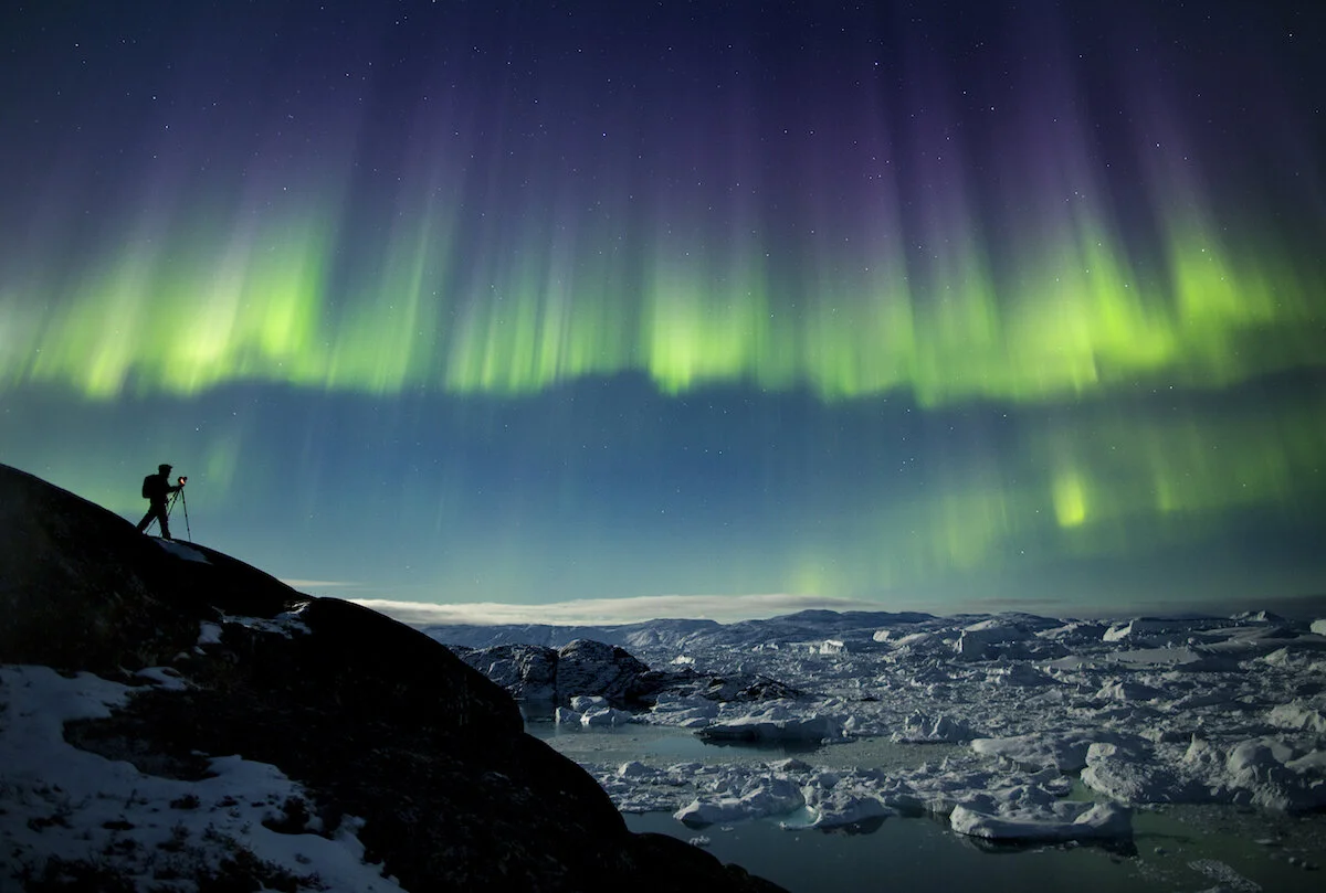
Despite the blizzard that set in shortly after setting up camp, we made good use of the next 48 hours by locating stunning ice caves and canyons within a kilometre of our tents. By the time the clear night came around, I had 4 or 5 shots I was after. I had a plan and a vision. Nightfall came cloudy, however, and we started getting concerned that our astrophotography plans would fall through. At midnight, we were still fighting the cloud cover despite all forecasts still calling for crystal clear conditions (I had re-checked with the InReach). Behind the veil, one could tell that the aurora was dancing. It was one of those situations where the images still looked great on the back of the cameras (due to the ice features being so photogenic), but every time we'd meet in the dark, one of us would say "Oh man, can you imagine if the clouds weren't there?!" Eventually, Stephen and Curtis decided to make their way back to camp and would shoot there if the skies cleared up. I opted to stick it out a little longer. After all, sunlight wouldn't come for another five hours and I had come all this way. Finally, at around 1 a.m., the cloud cover started dissipating quickly, revealing a bright ribbon of green.
I frantically ran around, crampons on, to re-create the four compositions I had scouted, and was able to frame the aurora borealis in all four. I've always felt I've had more than my share of luck with the aurora over the years. But that night was something else. This particular image was shot from the middle of a bend at the bottom of an ice canyon. The cold may have meant our blue lakes were gone, but it had enabled us to travel along the bottom of such canyons, thus opening up incredible compositions. I set up the tripod, went with settings of f/2.8, ISO 1600 and 10 seconds, manually focus on the rim of the canyon (where I would be standing), got the 5DIV to shoot continuously and then proceeded up the canyon, to a less steep section nearby and then up to the rim for the self-portrait. I placed my Lupine headlamp on the ground behind me to cast a bit of rim light on myself. I took about eight similar images and selected this one because it's the one where the aurora looked best.

Aurora and ice on the Greenland ice sheet. Photo by Paul Zizka Photography.
I hope you like the stories behind the images! I very much look forward to sharing a few more shots from that incredible night!
This image is available as a limited-edition print in a variety of sizes and format. See our online store for details!
Join me on Patreon for more “Behind the Image” video posts, which go into more detail and feature behind-the-scenes footage and my editing process from raw to final.

Land of Mystery: Easter Island
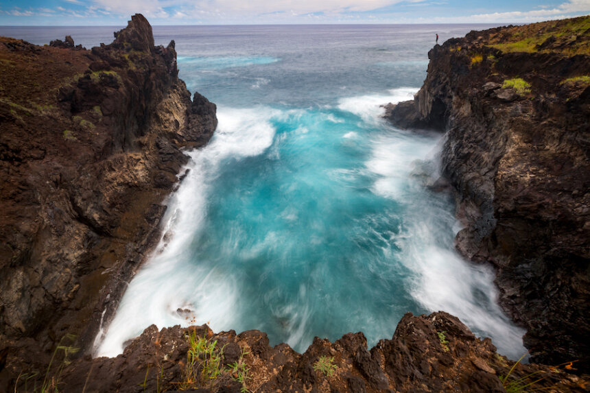
For a photographer, there is potential not just in capturing these ancient relics and photogenic statues, but also in the surrounding landscapes. Simply put: Easter Island is a beautiful place, with a rugged coastline, volcanic features, a gentle interior where wild horses roam, and turquoise-blue seas.
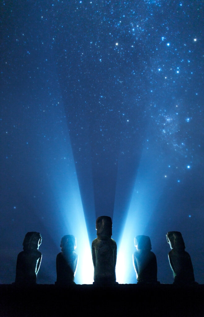
Easter Island, a relatively small speck of land remotely situated 3,512 kilometres off the coast of Chile, has intrigued travellers for centuries. Also known as Rapa Nui, the island and its history have a way of capturing the imagination of anyone who visits. A thousand Moai, enormous rock statues standing several metres high, "inhabit" the island. The work involved in carving a single statue is unfathomable. How they were transported and placed atop their Ahu (platforms), often tens of kilometres away from the rock quarry, remains one of the world's great unsolved mysteries.
For a photographer, there is potential not just in capturing these ancient relics and photogenic statues, but also in the surrounding landscapes. Simply put: Easter Island is a beautiful place, with a rugged coastline, volcanic features, a gentle interior where wild horses roam, and turquoise-blue seas.
With Polynesian roots and a more modern-day Chilean influence, Rapa Nui has a unique blend of cultures, food (hello, ceviche) and language. It is a remarkable place that truly lives up to its reputation. Here is a body of work from my visit back in February 2019!

Travelling Moai. Photo by Paul Zizka Photography.

Sunset at Ahu Tahai. Photo by Paul Zizka Photography.
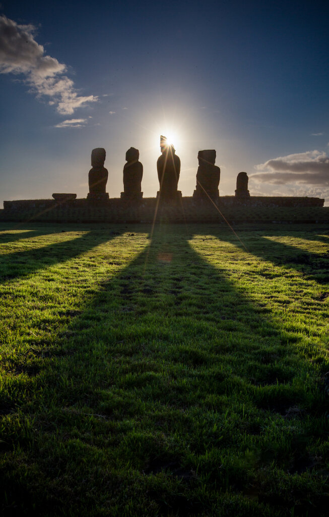
Sunset at Ahu Tahai. Photo by Paul Zizka Photography.

Moai at Rano Raraku. Photo by Paul Zizka Photography.

Rano Raraku. Photo by Paul Zizka Photography.

Self-portrait at Rano Kau. Photo by Paul Zizka Photography.

Poiku Peninsula, the wildest part of Easter Island. Photo by Paul Zizka Photography.

Poiku Peninsula, the wildest part of Easter Island. Photo by Paul Zizka Photography.

Poiku Peninsula, the wildest part of Easter Island. Photo by Paul Zizka Photography.

Colours of Ovahe. Photo by Paul Zizka Photography.

The islet of Motu Nui from Orongo. Photo by Paul Zizka Photography.

Sunrise at Tongariki. Photo by Paul Zizka Photography.

The wild coastline of Easter Island. Photo by Paul Zizka Photography.

Wild horses near the coast. Photo by Paul Zizka Photography.
All of these images are available as limited-edition prints in a variety of sizes and formats. Check out our Prints page for more information!

Ana Kakenga, a lava tube near the coast. Photo by Paul Zizka Photography.
Ana Kakenga, a lava tube near the coast. Photo by Paul Zizka Photography.
Nighttime at Ahu Tongariki. Photo by Paul Zizka Photography.

Ahu Tongariki. Photo by Paul Zizka Photography.

Ahu Tongariki. Photo by Paul Zizka Photography.

Ahu Tahai. Photo by Paul Zizka Photography.

Ahu Tahai. Photo by Paul Zizka Photography.

Ahu Huri a Urenga, the only Moai with four hands. Photo by Paul Zizka Photography.

Extreme Blues and Bobbing by Icebergs: Antarctica
This latest trip to Antarctica was one for the memory books, filled with its highs and lows (including 7-metre waves in the Drake Passage!) and inclement weather that finally gave way to an incredible experience: five hours riding zodiacs through Charlotte Bay to photograph whales, iceberg and epic scenery. I'm already missing the sense of remoteness, scale and grandeur.
This latest trip to Antarctica was one for the memory books, filled with its highs and lows (including 7-metre waves in the Drake Passage!) and inclement weather that finally gave way to an incredible experience: five hours riding zodiacs through Charlotte Bay to photograph whales, iceberg and epic scenery. I'm already missing the sense of remoteness, scale and grandeur.
I have 7,000 or so frames to go through but wanted to show you an initial set of images! Enjoy this window into the latest journey to the White Continent.
As always, all images are available as limited-edition prints in a variety of sizes and format.

Fur seals swimming in impossibly blue water. Photo by Paul Zizka Photography.
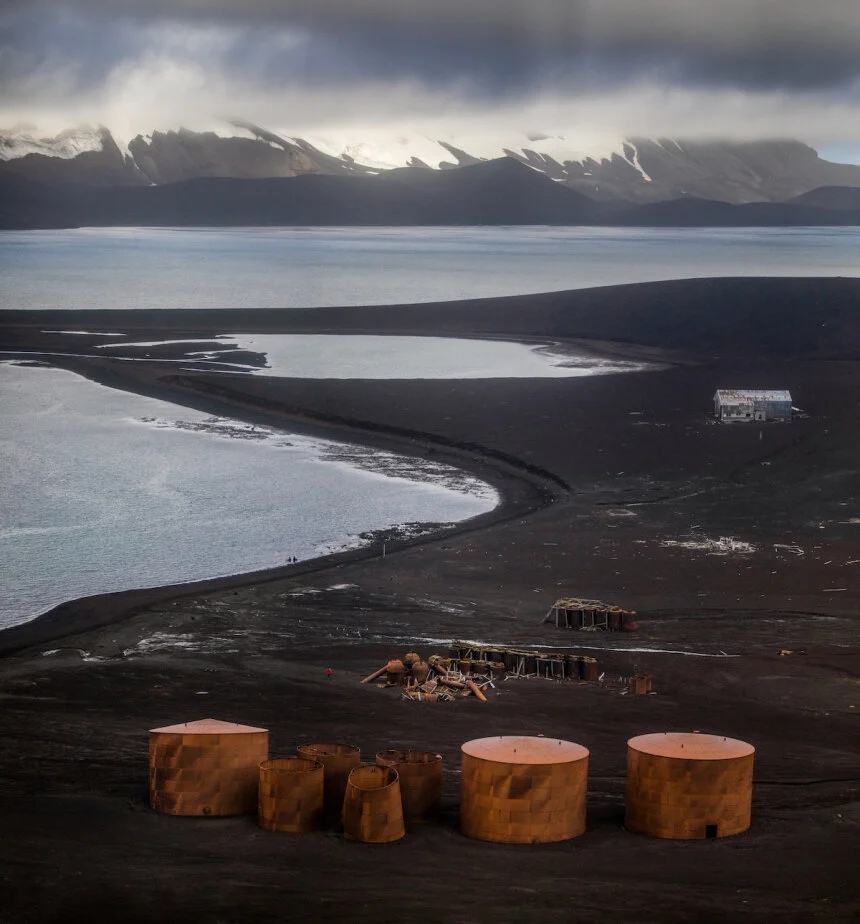
Deception Island. Photo by Paul Zizka Photography.

A mammoth iceberg. Photo by Paul Zizka Photography.

Moonrise over the Antarctic Peninsula. Photo by Paul Zizka Photography.

Huge ice features. Photo by Paul Zizka Photography.

Fur Seal on Deception Island. Photo by Paul Zizka Photography.

Stunning details in icebergs. Photo by Paul Zizka Photography.

Gentoo penguins at Dorian Bay. Photo by Paul Zizka Photography.

Zodiac provides a sense of scale to the enormity of the landscape. Photo by Paul Zizka Photography.
Peleno Strait. Photo by Paul Zizka Photography.

10 Favourite Places to Shoot the Northern Lights
I’ll admit it: the northern lights are intoxicating. For many years I’ve been drawn to cold, northerly destinations, both as a photographer and an adventurer. And beyond the desolate beauty and landscapes of these locations, whether it’s Greenland or Canada’s northern territories, it’s icing on the cake that they also provide us with the best opportunities to shoot the aurora borealis.
I’ll admit it: the northern lights are intoxicating. For many years I’ve been drawn to cold, northerly destinations, both as a photographer and an adventurer. And beyond the desolate beauty and landscapes of these locations, whether it’s Greenland or Canada’s northern territories, it’s icing on the cake that they also provide us with the best opportunities to shoot the aurora borealis.
Here are my top 10 favourite locations around the globe to shoot the northern lights, in no particular order of preference:
1. Alaska
In a nutshell: Perfect latitude, fantastic scenery to pair up with lights. Cloud cover can be an issue.
When to go: October to March.

Denali National Park, Alaska, USA. Photo by Paul Zizka Photography.
2. Canadian Prairies
In a nutshell: Nice low horizon, easy access. You need a decent show.
When to go: Year-round.
Canadian Prairies. Photo by Paul Zizka Photography.
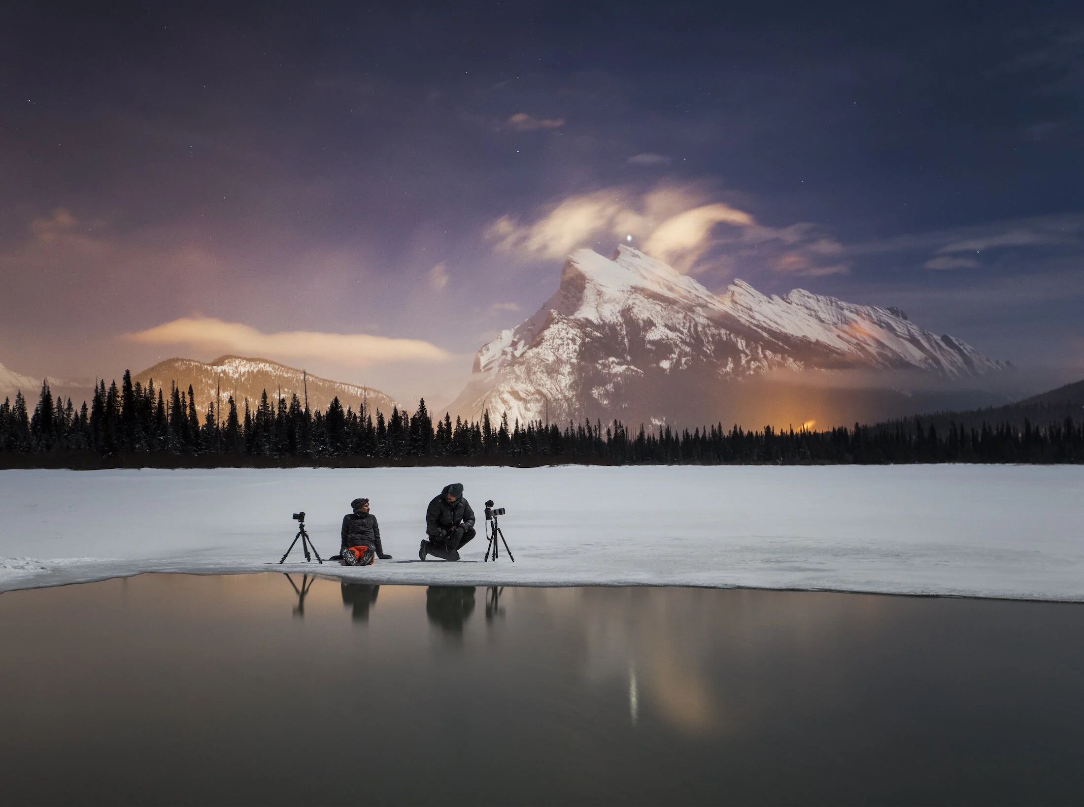
3. Canadian Rockies
In a nutshell: Some of the most incredible skylines to pair with lights. Great displays are rare. High horizons make it more challenging to shoot.
When to go: Year-round.

Banff National Park. Photo by Paul Zizka Photography.
→ Check out these Resources for Shooting the Canadian Rockies.
4. Greenland
In a nutshell: Zero light pollution, mind-blowing scenery. More difficult/expensive to access. Strong displays frequent.
When to go: September to April.
Greenland. Photo by Paul Zizka Photography.
→ You’ll also find my Aurora Watching Web Resources here.
5. Iceland
In a nutshell: Easier, cheaper access. Weather can be an issue. Good latitude, great landscapes. More people.
When to go: September to April.

Iceland. Photo by Paul Zizka Photography.
6. Labrador
In a nutshell: Super dark skies, very wild. Access can be difficult. Some incredible skylines.
When to go: September to April.

Torngat Mountains National Park. Photo by Paul Zizka Photography.
7. Norway
In a nutshell: Good latitude. Stunning landscapes. Weather can be an issue.
When to go: September to April.

Norway. Photo by Paul Zizka Photography.
8. Nunavut
In a nutshell: Very little light pollution, incredible scenery. Lower temperatures to deal with. More difficult/expensive to access. Strong displays frequent.
When to go: September to April.

Nunavut. Photo by Paul Zizka Photography.
9. Northwest Territories
In a nutshell: Very little light pollution, low horizons, surprisingly great access. Strong displays very frequent.
When to go: September to April.

Yellowknife, Northwest Territories. Photo by Paul Zizka Photography.
10. Yukon
In a nutshell: Very little light pollution, fairly easy/inexpensive access. Great latitude for aurora.
When to go: September to April.

→ Check out my Aurora Watching Web Resources

Journey to the White Continent
It always seemed so unattainable to me. But after two days at sea, and a year of anticipation, I was mesmerized when we first caught sight of a few rocks off Elephant Island through the thick fog – harbingers of our imminent arrival on the fabled White Continent. There is no wilder place on Earth, nowhere more remote, more inhospitable.
Antarctica.
It always seemed so unattainable to me. But after two days at sea, and a year of anticipation, I was mesmerized when we first caught sight of a few rocks off Elephant Island through the thick fog – harbingers of our imminent arrival on the fabled White Continent. There is no wilder place on Earth, nowhere more remote, more inhospitable.
And as I found out over the six weeks following that moment in early January 2017, you’d be hard-pressed as a photographer to find another location on the planet that is more overwhelming. The photo opportunities just kept on coming, and I’ll never forget the sense of remoteness, the way life thrived on a whole other level, and the scale of the land down there. I’m thankful for One Ocean Expeditions for bringing me on board.
Amazingly, I managed to underestimate how many photographs I would take on the trip. When I returned home from the White Continent, the hard drives were filled to the brim, and between test shots, time-lapses, bracketed sequences and such, I came home with 40,000 files! I’m just starting to put a dent into all that material, but I would like to share some of the early results with you.
Antarctica is a place that will stay with me forever, and I very much look forward to revisiting my experience there through the thousands of photographs. I hope you enjoy the sneak peek!

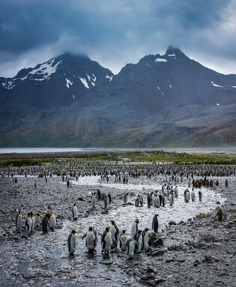
The scale of South Georgia is absolutely overwhelming. Massive mountains grace the horizon. Glaciers are colossal. Penguins come by the thousands. Fur seals are everywhere you look. And the island itself is 2,000 km from the nearest mainland – isolation beyond description. I took this from our ship, the Vavilov, on an early morning at Gold Harbour, a place of incredible beauty. This is a penguin highway, which is simply a path of least resistance the animals continuously follow. In the back is the rapidly receding, spectacular Bertrab Glacier. By the way, the Canon 100-400 was by far my most used lens on the trip. Photo by Paul Zizka Photography.

I’ve taken my share of selfies, but never with penguins, fur seals and elephant seals looking on. That morning at St Andrews Bay was a highlight of the time spent on South Georgia with One Ocean Expeditions. Photo by Paul Zizka Photography.

A trio of synchronized whales swim into the endless Antarctica sunset. We saw dozens, perhaps hundreds of cetaceans that evening in the Gerlache Strait. The ice and mountains alone were just breathtaking. Photo by Paul Zizka Photography.
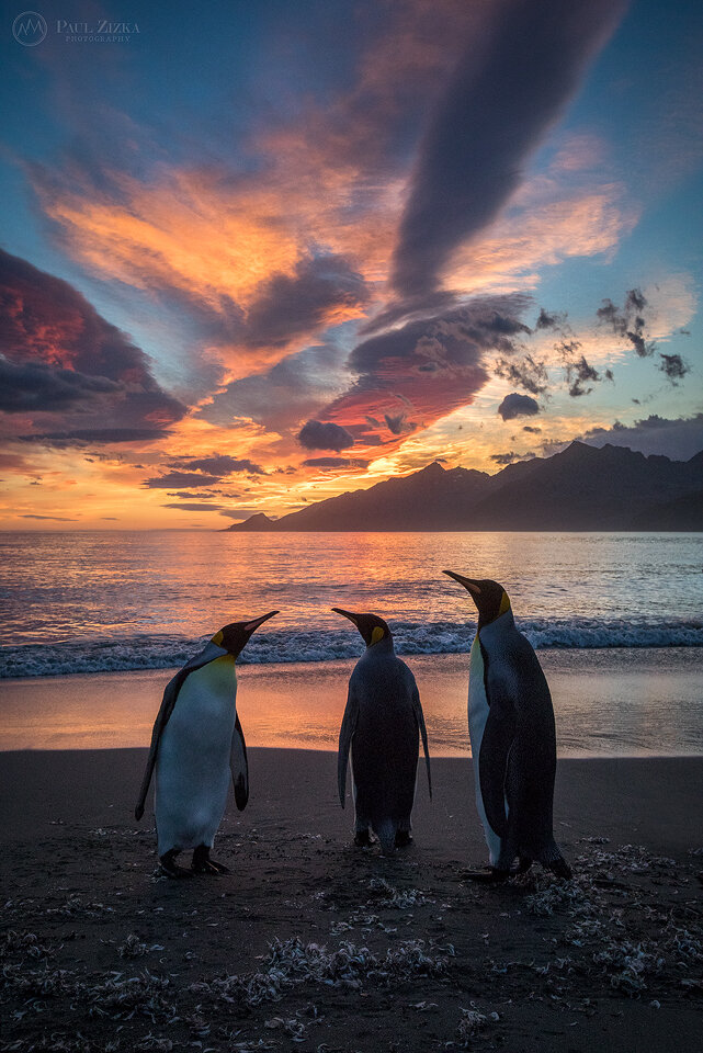
They had warned me that South Georgia would turn anyone into a wildlife photographer… Hard to ignore those three king penguins backlit by a fiery sunrise. This was at St Andrews Bay, meaning there were another 100,000 penguins right behind me. Just mind-blowing. I’d never seen life thrive at that level. This is the largest penguin colony on the island. Photo by Paul Zizka Photography.

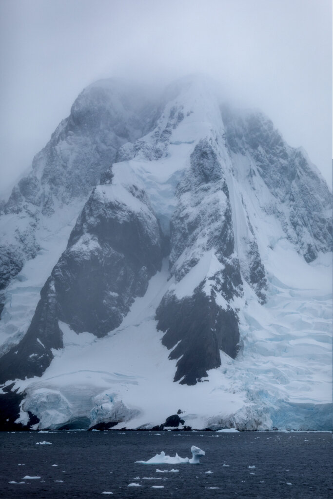
Love the mysterious, deep blue hues of Antarctic icebergs… Lemaire Channel, Antarctica. Photo by Paul Zizka Photography.

This was one of the most entertaining wildlife encounters we had on South Georgia: a macaroni penguin and a blue-eyed shag fighting over a little rock island. I think I took 100 shots of that interaction, but with the subjects moving and the zodiac bobbing around on the waves, I never quite got the composition where I want it… This is the best one of the lot. A wonderful wildlife moment in the middle of nowhere. Photo by Paul Zizka Photography.

A self-portrait taken on Petermann Island on the Antarctic peninsula. Between the gentoo penguins, the huge icebergs floating by, and the distant glaciated peaks, this is one place I found particularly overwhelming as a photographer. Just incredible. Photo by Paul Zizka Photography.
As we explored the coast of the island that morning, we all did our best to simplify our compositions, usually by isolating one or two animals. But the truth is, South Georgia is an incredibly cluttered place. It’s a compositional mess of colours, textures and lines. So here’s a crowded image I feel is representative of that amazing island! A lot of the detail is lost here on social media but I hope it conveys a sense of the place. Fortuna Bay, South Georgia. Photo by Paul Zizka Photography.

Ice in Antarctica comes in all shapes, sizes, textures and shades of blue. A paradise for the cryophile. The turquoise ramparts of this iceberg were particularly mesmerizing. Paradise Harbour, Antarctica. Photo by Paul Zizka Photography.
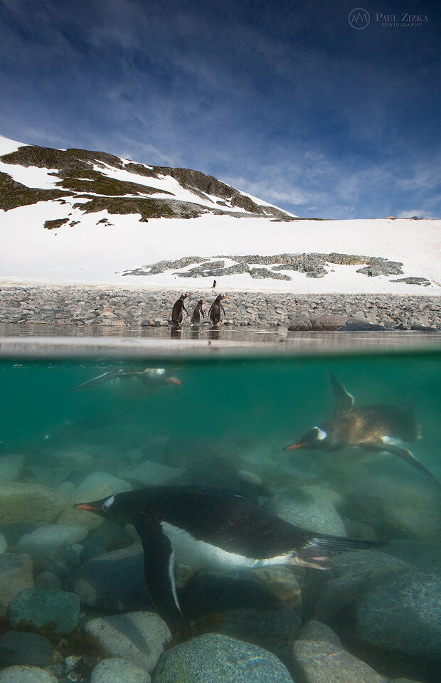
I think it’s fair to say gentoo penguins look rather clumsy above the surface. Underwater though, they move with incredible speed and precision. I took 500 shots. A handful had penguins in them… Photo by Paul Zizka Photography.

Gloomy morning at Fortuna Bay, South Georgia. Photo by Paul Zizka Photography.

Hiking on the peninsula, a sacred place. For me, every step was a privilege in that precious, stunning part of the world. In the background is the Conscripto Ortiz refuge, run by Argentina. Paradise Harbour, Antarctica. Photo by Paul Zizka Photography.

Camping on the 7th continent… Would you? I settled into my “moat” for the obligatory self-portrait and then realized the surroundings were just too good to pass up. I spent a sleepless, exhilarating, peaceful night exploring and photographing beautiful Leith Cove before returning to the ship. Leith Cove, Antarctica. Photo by Paul Zizka Photography.

Penguin life has its challenges. Gruesome, I know, but a reminder that leopard seals and other predators constantly prowl the icy waters of the Antarctic peninsula (good thing to keep in mind for the underwater photographer too I suppose). Danco Island, Antarctica. Photo by Paul Zizka Photography.

I really wished I hadn’t used the word “epic” so much before going to Antarctica. I think we all ran out of superlatives soon after reaching the continent… Gerlache Strait, Antarctica. Photo by Paul Zizka Photography.

Brash ice, cirrus clouds and mammoth peaks – a perfect afternoon on the White Continent. Photo by Paul Zizka Photography.

An Adelie penguin reaches the extent of the sea ice, Antarctica. Photo by Paul Zizka Photography.

Self-portrait at the edge of the world. Photo by Paul Zizka Photography.
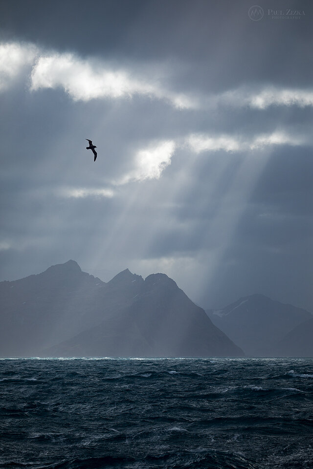
An albatross conveniently soars through the frame as crepuscular rays rain down on the peaks of South Georgia. So much beauty in that remote corner of the world. Photo by Paul Zizka Photography.

Iceberg illuminated by the sun, Antartica. Photo by Paul Zizka Photography.

A lone Adelie penguin seemingly runs out of sea ice off of the Antarctic peninsula. As for us, we ran out of water. This encounter marked the southernmost extent of our journey: about 67 degrees, somewhere in Lallemand Fjord. Photo by Paul Zizka Photography.

Journey Through the Torngat Mountains
The Torngats. The name alone evokes a sense of mystery. Tucked into one of the most remote parts of Canada lies one of the last frontiers for landscape photographers and explorers alike: the Torngat Mountains
The Torngats.
The name alone evokes a sense of mystery. Tucked into one of the most remote parts of Canada lies one of the last frontiers for landscape photographers and explorers alike: the Torngat Mountains. The area is an incredibly wild mix that fires up the imagination: Norway-like fjords, glacier remnants (and the associated turquoise lakes), a healthy polar bear population, jagged icebergs freshly arrived from Greenland, aurora-filled skies, cultural treasures, archeological gems, rich marine life, and some of the highest, most rugged peaks in all of Eastern Canada.
Best of all, all that incredible wilderness is now protected through the national parks system, and it is accessible to the adventurous-minded via the recently-established Torngats Base Camp.
It is a deeply sacred home to Inuit people and, back in August 2016, I had the incredible opportunity to spend a week in the area. It is truly amazing to be able to be among the first to document all that beauty with the camera. Not only that, but being able to do so in great comfort (especially given the remoteness). The facilities were top-notch, the local staff were most helpful and access to the landscape via zodiacs was as exciting as convenient.
The Torngats are truly a place you have to see for yourself. No words can do the place justice. It's like a modern-day Shangri-la, an overwhelming paradise for landscape and wildlife photographers. Even images don't get close to depicting what the Torngats are like, here's my attempt through my favourite images from the week!
→ All of these images are available as custom limited edition prints.

The Goose Bay area has great photos ops on the way up to the Torngats! Photo by Paul Zizka Photography.

The Goose Bay area. Photo by Paul Zizka Photography.

Unnamed Waterfall, Torngat Mountains, Labrador. Photo by Paul Zizka Photography.

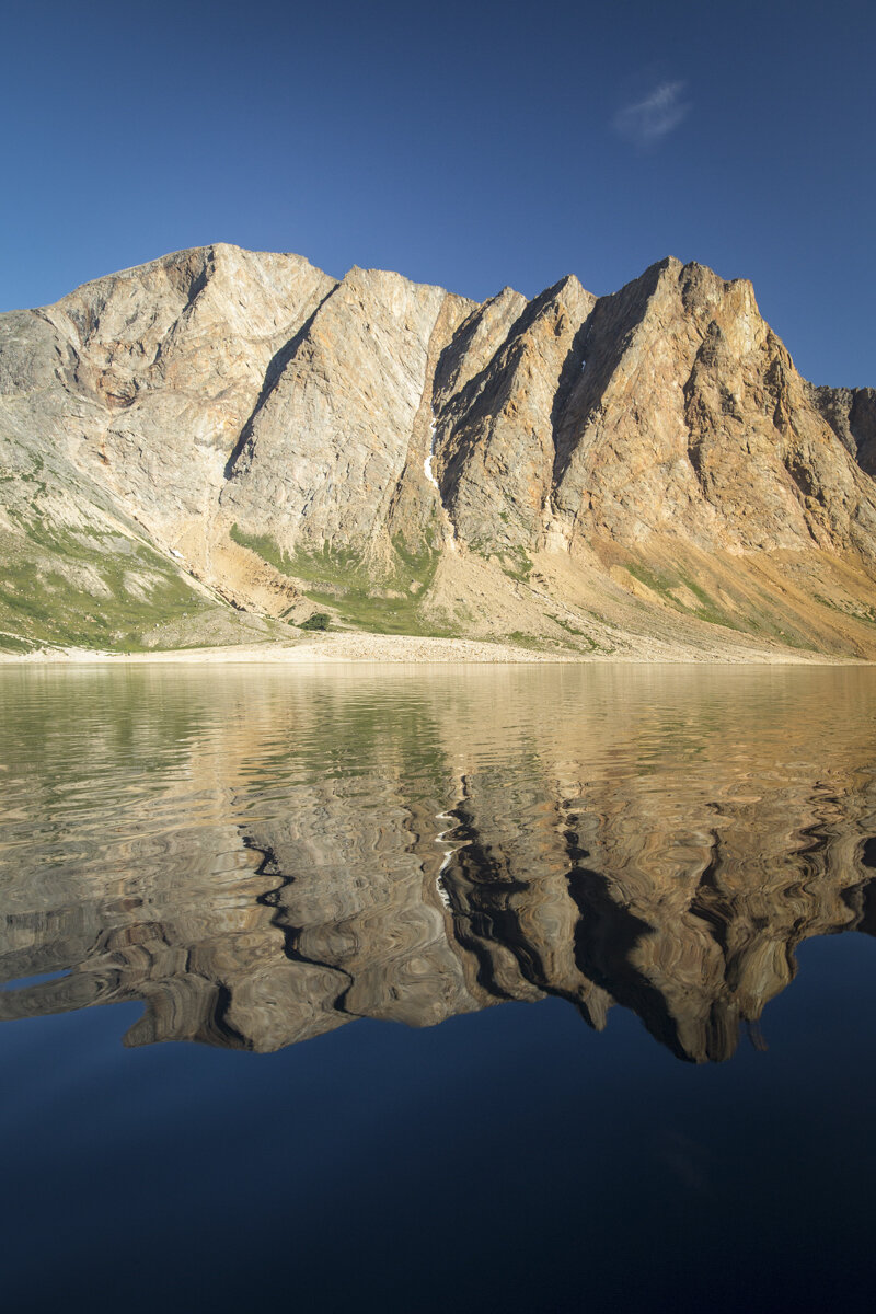
Unnamed lake, Torngat Mountains, Labrador. Photo by Paul Zizka Photography.

Unnamed Waterfall, Torngat Mountains, Labrador. Photo by Paul Zizka Photography.

"Aurora Harbour" 3 AM in the Torngats. The aurora borealis paints an incredible scene in the Labrador sky. Torngat Mountains National Park. Photo by Paul Zizka Photography.

The aurora borealis paints an incredible scene in the Labrador sky. Torngat Mountains National Park. Photo by Paul Zizka Photography.

Aurora Borealis, Torngat Mountains National Park. Photo by Paul Zizka Photography.

Moody day at Saglek Fjord, Torngat Mountains National Park, Labrador. Photo by Paul Zizka Photography.

North Arm, Torngat Mountains National Park, Labrador. Photo by Paul Zizka Photography.
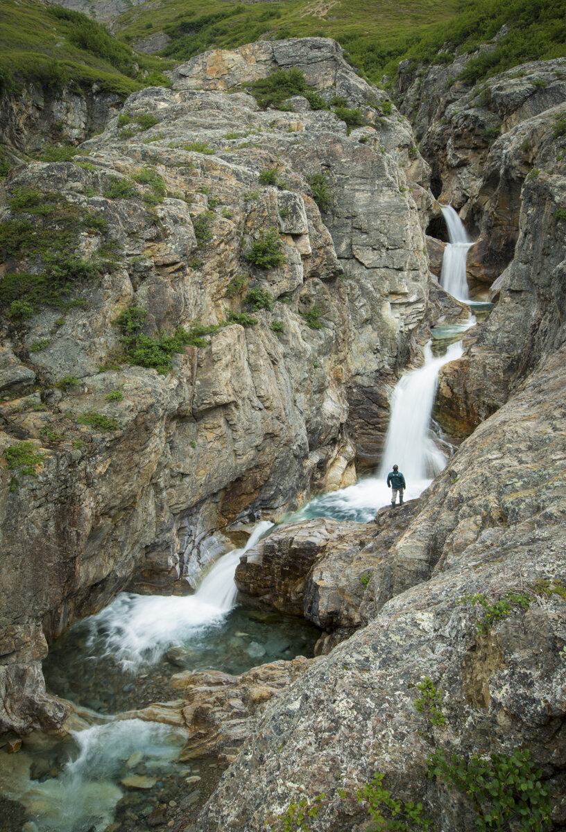
Even the local Parks staff never tire of the magic of the Torngats! Unnamed waterfall near North Arm, Torngat Mountains National Park, Labrador. Photo by Paul Zizka Photography.

A moment of bliss in the Torngats, sitting at the front of the boat, gazing out at the symmetry and the deep blue waters around us, and wondering what will lie around the next corner. Photo by Paul Zizka Photography.

North Arm, Torngat Mountains National Park, Labrador. Photo by Paul Zizka Photography.

Sitting at the front of the boat, gazing out at the symmetry and the deep blue waters around us, and wondering what will lie around the next corner. Photo by Paul Zizka Photography.

"Torngats Glory" Just another beautiful, unnamed tumble of the Torngats. That morning it looked like Mother Nature has applied the "mosaic" filter to the reflections. Photo by Paul Zizka Photography.
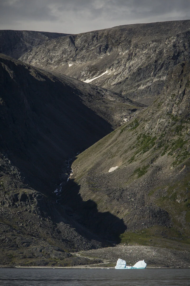
Big iceberg, bigger cliffs. Saglek Fjord, Torngat Mountains National Park. Photo by Paul Zizka Photography.

"The Face" of SW Arm. Saglek Fjord, Torngat Mountains National Park. Photo by Paul Zizka Photography.

The Goose Bay area has great photos ops on the way up to the Torngats! Photo by Paul Zizka Photography.

Drying fish at Base Camp. Photo by Paul Zizka Photography.
"Northern Ramparts" The placid waters of the iconic Southwest Arm reflect an oil painting-like rendition of the cliffs towering above. The colourful wall rises nearly 1,000 metres above the fjord. It looks so much more impressive in person. :-) Photo by Paul Zizka Photography.

Welcome to the Torngats! Photo by Paul Zizka Photography.

View over St. John's Harbour and Base Camp from "the inukshuk". Torngat Mountains, Labrador. Photo by Paul Zizka Photography.

Iceberg off shore, Torngat Mountains. Photo by Paul Zizka Photography.

"Northern Ramparts" The placid waters of the iconic Southwest Arm reflect an oil painting-like rendition of the cliffs towering above. The colourful wall rises nearly 1,000 metres above the fjord. It looks so much more impressive in person. :-) Photo by Paul Zizka Photography.

Morning at St. John's Harbour, right next to Base Camp. Photo by Paul Zizka Photography.

Windex Lake as seen from the air. Photo by Paul Zizka Photography.

Ramah Bay as seen from the air. Photo by Paul Zizka Photography.

Rugged coastline of the Torngats as seen from the air. Photo by Paul Zizka Photography.

Rugged coastline of the Torngats as seen from the air. Photo by Paul Zizka Photography.
Nachvak Fjord from the air, Torngat Mountains National Park. Photo by Paul Zizka Photography.
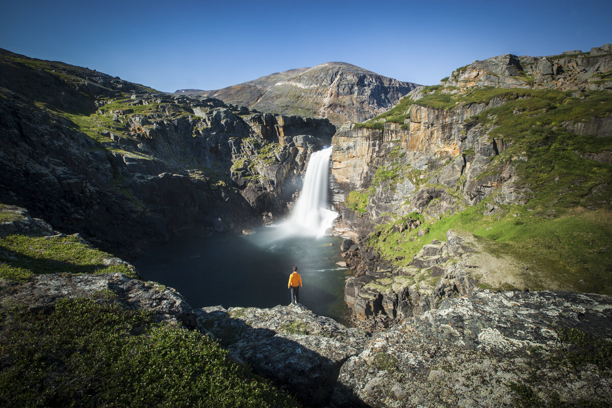
"Labrador Magic." The incredible, raging Nakvak Falls, deep in Torngat Mountains National Park. This gem is reached either by flying or walking a looong way. I cheated for this one. There was only enough time for a few quick, safe shots, and off we went again! Thanks to pilot Steve for an incredible morning up high!

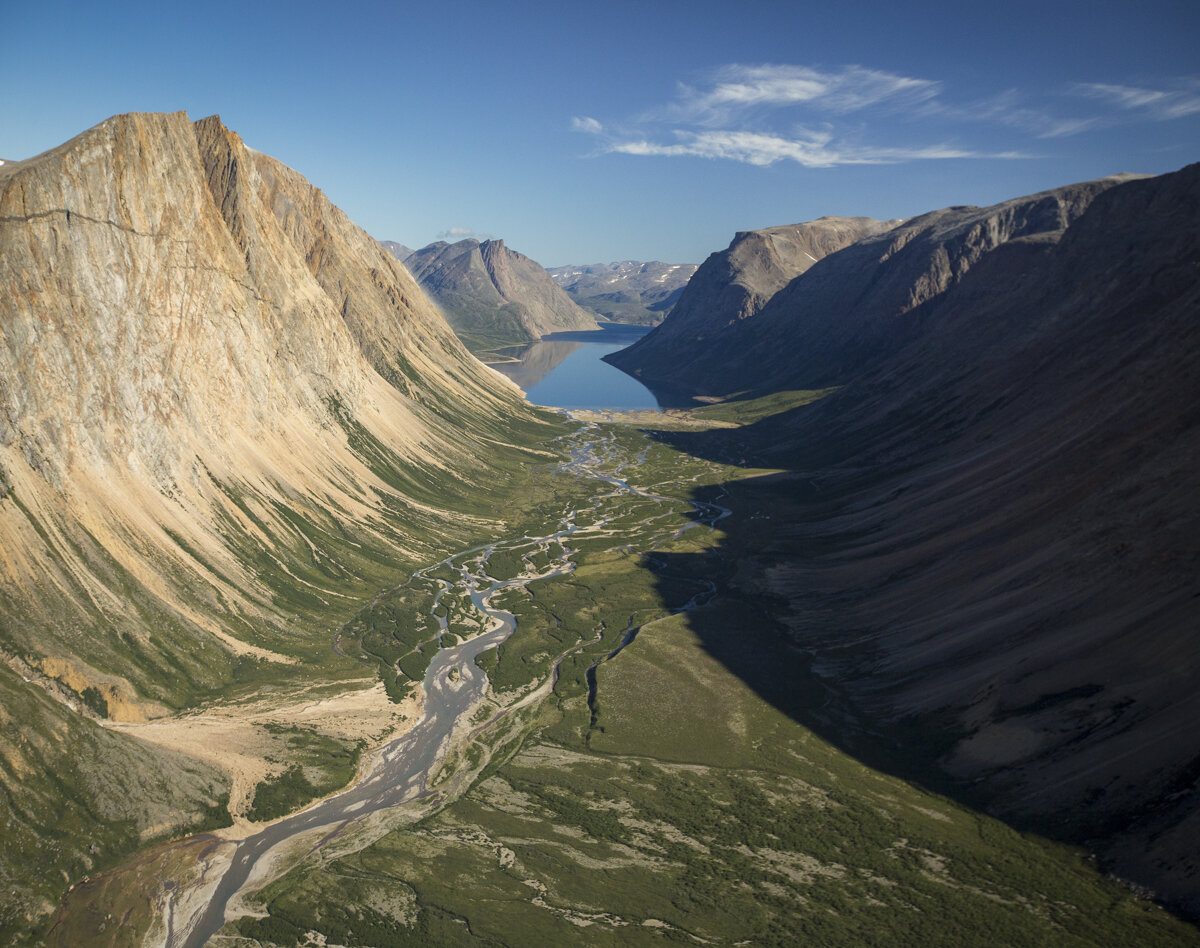
"Forgotten World." Of all the images I have posted from the Torngat Mountains National Park so far, this aerial view of the Southwest Arm is probably the one that is most representative of what the place is like. Part Norway, part Canadian Rockies, part Nunavut, yet unlike anywhere else I have gone before. Photo by Paul Zizka Photography.

Aurora, noctilucent clouds and the first light of dawn paint an incredible scene in the Labrador sky. Torngat Mountains National Park. Photo by Paul Zizka Photography.

Self-portrait in Torngat Mountains National Park, Labrador. Photo by Paul Zizka Photography.

"Crayola Point." That is how we started referring to that 15-foot high lichen-covered spire. A bluebird day at that location really brings out the entire array of colours one finds in the Torngat Mountains. Photo by Paul Zizka Photography.

Drifter... An underwater look at the fjords of Torngat Mountains National Park, complete with jellyfish. Photo by Paul Zizka Photography.
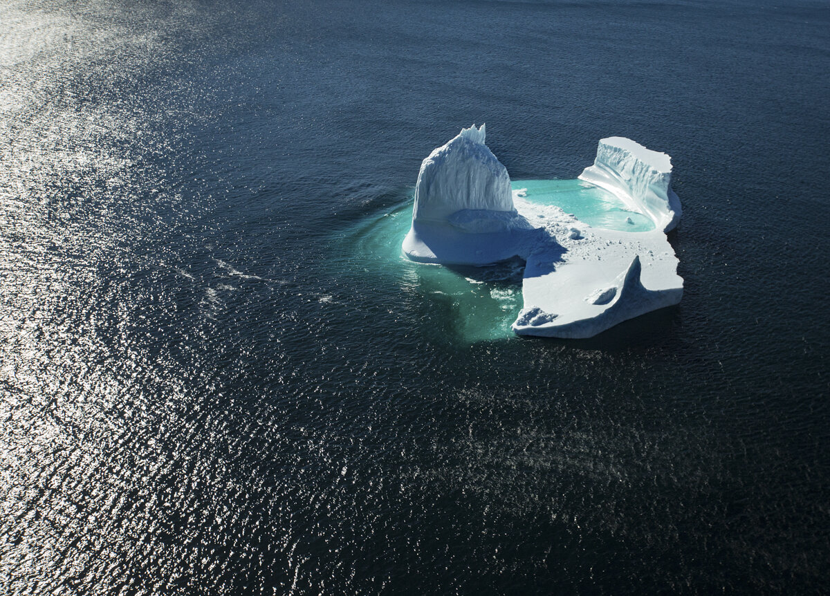
Iceberg off the coast of the Torngat Mountains National Park, Labrador. Photo by Paul Zizka Photography.
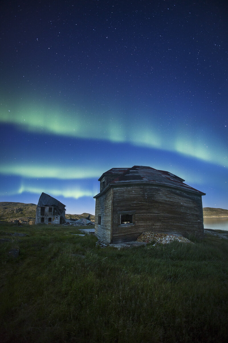
"Warp Zone." Aurora over the abandoned, twisted Hudson Bay buildings of Hebron. The second I saw images of that remote, nearly deserted Moravian mission (only one family remains), I knew I wanted to photograph it at night. Big thanks to The Torngats Base Camp for getting me out there, and to bear guard Joe for working after hours and wandering around the site with me! Photo by Paul Zizka Photography.

Wild teetering iceberg, Torngat Mountains National Park. Photo by Paul Zizka Photography.
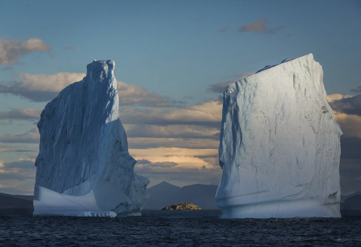
"Framed In Ice". Last light on the behemoths of the Labrador coast. These towers were approximately 30 metres high. I took a flurry of shots, trying to frame that little island as the light was fading and the boat was bobbing. Thankfully one of the frames worked out! Torngat Mountains, Labrador. Photo by Paul Zizka Photography.

Unnamed turquoise lake near North Arm, Torngat Mountains National Park. Photo by Paul Zizka Photography.

Black Bear Tracks, Unnamed lake near North Arm, Torngat Mountains National Park. Photo by Paul Zizka Photography.

Ramparts of the Southwest Arm, Torngat Mountains National Park. Photo by Paul Zizka Photography.

Marine life, Torngat Mountains National Park. Photo by Paul Zizka Photography.

King of the hills. Large, healthy polar bear roaming among some of the world's oldest rocks. Torngat Mountains National Park, Labrador. Photo by Paul Zizka Photography.

Large, healthy polar bear roaming among some of the world's oldest rocks. Torngat Mountains National Park, Labrador. Photo by Paul Zizka Photography.

Abandoned, twisted Hudson Bay buildings of Hebron, Labrador. Photo by Paul Zizka Photography.
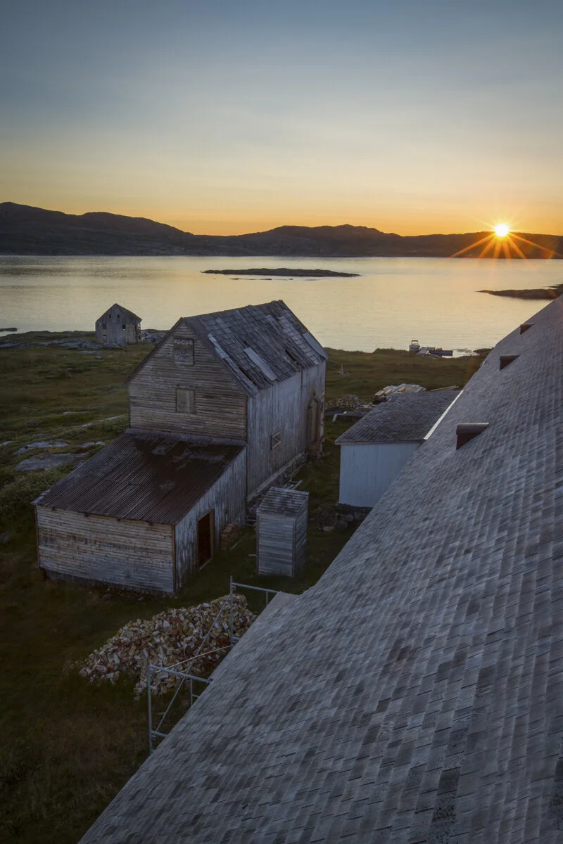
Rooftop sunrise, Hebron Moravian mission, Labrador. Photo by Paul Zizka Photography.

Watching the nearly-nightly aurora borealis display from my tent, Torngat Mountains Base Camp. Photo by Paul Zizka Photography.