Documenting the Sundhnúkagígar Eruption in Iceland
Iceland has long captivated me with its dramatic landscapes shaped by volcanic activity. Even before I became a photographer, I was enthralled by this island. At the conclusion of my undergrad in Earth and Ocean Sciences, I walked across Iceland and became familiar with its rugged terrain. Since then, I have returned several times, including this month when the Sundhnúkagígar eruption occurred.
Iceland has long captivated me with its dramatic landscapes shaped by volcanic activity. Even before I became a photographer, I was enthralled by this island. At the conclusion of my undergrad in Earth and Ocean Sciences, I walked across Iceland and became familiar with its rugged terrain. Since then, I have returned several times, including this month when the Sundhnúkagígar eruption occurred.

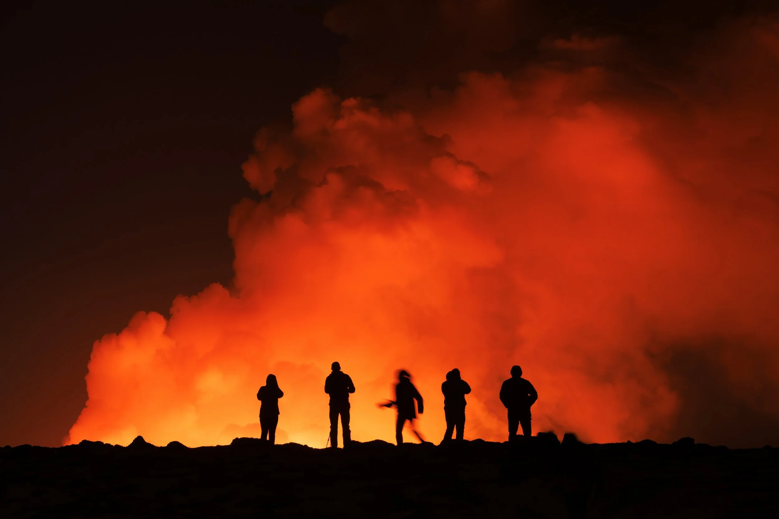
Our OFFBEAT group capturing the eruption later on the day we were evacuated, from a safe distance. Photo: Paul Zizka.
I was staying at the Northern Light Inn with a group, co-leading an OFFBEAT photography workshop, when on our last morning we were awoken very early by the call to evacuate. Just two kilometres away, a volcano erupted along a three-kilometre fissure northeast of Mount Sýlingarfell. We promptly packed our bags and within 20 minutes were walking to our vehicles to join a convoy away from the area. Soon, we got sight of the lava fountains shooting 80 metres into the air. It was an unforgettable experience, and somewhat painful for a group of photographers who would have loved to capture it on camera. But, safety first - we got out and soon after the lava flowed across the road.
CBC’s The National featured the events and a short interview with me on February 12, 2024.
Later, from a safe distance our group was able to observe and photograph the eruption. It will stand as one of the most remarkable and surreal experiences of my life. I am grateful there was no loss of life, though the lava did burst a major water pipeline, leaving several communities on the Reykjanes Peninsula without heat and hot water.
Here are a few more photographs and videos from the events that transpired that memorable experience.
→ I’m heading back to Iceland in 2026 with OFFBEAT! Learn more here and join us for this next adventure!

Workshop participants capturing an unforgettable moment. Photo: Paul Zizka.

A self-portrait taken with the distant lava fountains (Canon RF100-500). Photo: Paul Zizka.
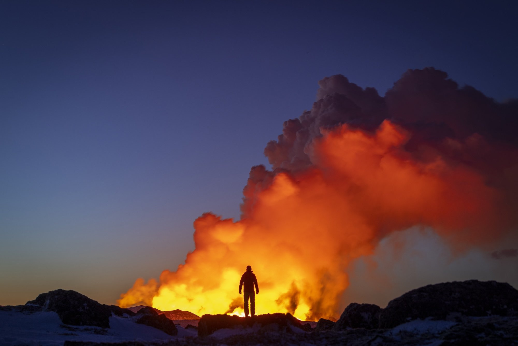
Self-portrait with the Sundhnúkagígar Eruption in Iceland. Photo: Paul Zizka.

Sundhnúkagígar Eruption in Iceland. Model Kris Andrea. Photo: Paul Zizka.
See more in the news:
Iceland's erupting volcano an 'unforgettable' close encounter, says Alberta photographer
If any of these images catches your eye, please reach out to me for any custom print orders. I’m happy to print in a variety of sizes and formats.
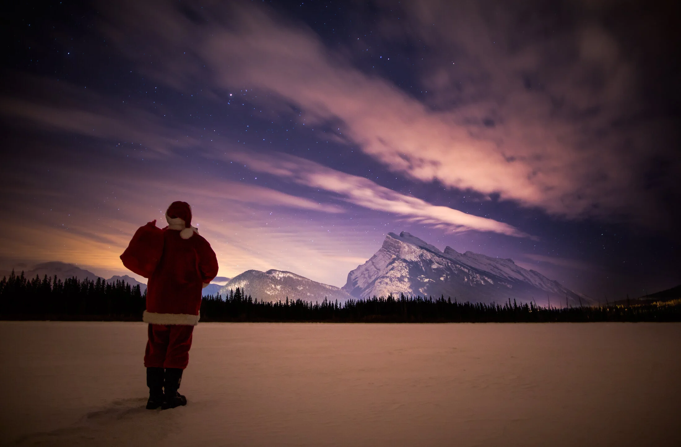
The Wild Santa Series
He may be plump and jolly, but this big guy can do a whole lot more than just ride a sleigh all over the world in one night. He’s been spotted in the Canadian Rockies on several occasions (hard to miss, he’s always wearing bright red), but you might be surprised at what he’s been up to when he’s not delivering toys…
He may be plump and jolly, but this big guy can do a whole lot more than just ride a sleigh all over the world in one night. He’s been spotted in the Canadian Rockies on several occasions (hard to miss, he’s always wearing bright red), but you might be surprised at what he’s been up to when he’s not delivering toys…
No AI at work here.
Thanks to everyone who has helped me create this Wild Santa series over the years - a tradition first started back in 2014. 😉

Santa burning off some cookies at Vermilion Lakes. Model: Kristen Thorogood. Photo: Paul Zizka Photography.

He sees you when you’re skating. Model: Magali Cote. Photo: Paul Zizka Photography.

Christmas Eve in Banff, Alberta. Model: Self-portrait. Photo: Paul Zizka Photography.
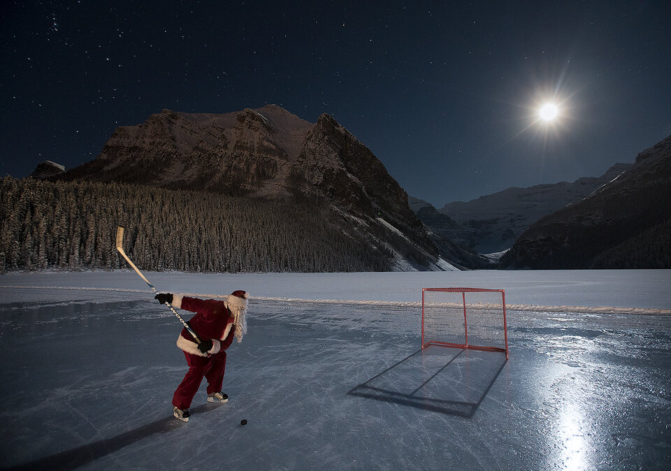
While you were sleeping…. hockey on Lake Louise, Alberta. Model: Lee Nordbye. Photo: Paul Zizka Photography.

Santa takes a break from kids sitting on his knee and goes for a SUP. Model: Sue Shih. Photo: Paul Zizka Photography.

Training for chimney climbing. Model: John Price. Photo: Paul Zizka Photography.

Mrs. Claus takes over in Banff, Alberta. Model: Davina Bernard. Photo: Paul Zizka Photography.
Santa departing the North Pole (Saskatchewan Glacier). Model: John Bennett. Photo: Paul Zizka Photography.

Santa can do more tricks than just delivering toys around the world. On skates at Lake Louise. Model: Bryce Chudak. Photo: Paul Zizka Photography.

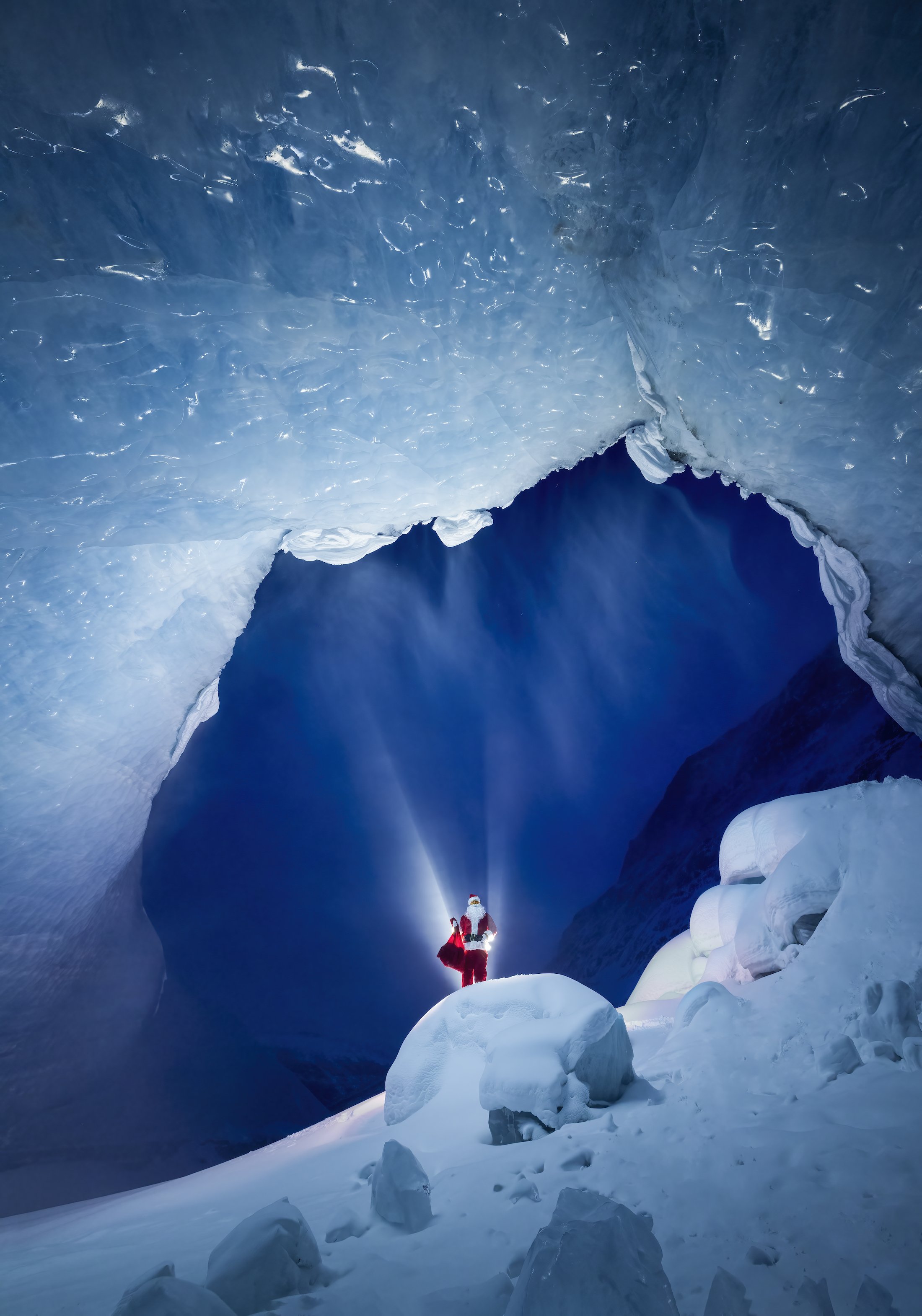
Santa, the glacier explorer. Model: Lee Nordbye. Photo: Paul Zizka Photography.
Land of the Eternal Blue Sky: 5 Favourite Images From Mongolia
It seems impossible to take a bad photo in Mongolia. With towering sand dunes that glow during magic hour, vast landscapes that seem to stretch on for eternity, and welcoming people who share their traditional way of life and—a photographer will find endless possibilities. It’s no wonder that OFFBEAT returned to the “Land of the Eternal Blue Sky” this June to host two photography workshops: The Gobi Desert and The Wild West.
It seems impossible to take a bad photo in Mongolia. With towering sand dunes that glow during magic hour, vast landscapes that seem to stretch on for eternity, and welcoming people who share their traditional way of life and—a photographer will find endless possibilities. It’s no wonder that OFFBEAT returned to the “Land of the Eternal Blue Sky” this June to host two photography workshops: The Gobi Desert and The Wild West.
After a long commute from Canada (in my case) to Mongolia, we were gifted with smooth logistics, perfect weather, and incredible light. Although I spent most of my time focused on leading these workshops, I managed to come home with thousands of photos. I’ve sifted through them all and am excited to share my 5 favourite images along with the story behind each one.
View the collection of Mongolia images available as Limited Edition Prints!

1. “Khongoryn Els”
A tight frame of sand dunes where every single pixel is 100% sand. I have been to this location before and fell in love with shooting more intimate scenes within the scene. Upon arrival in the Gobi Desert, I started to seek out these compositions. I shot a number of those images that day and this is my favourite one.
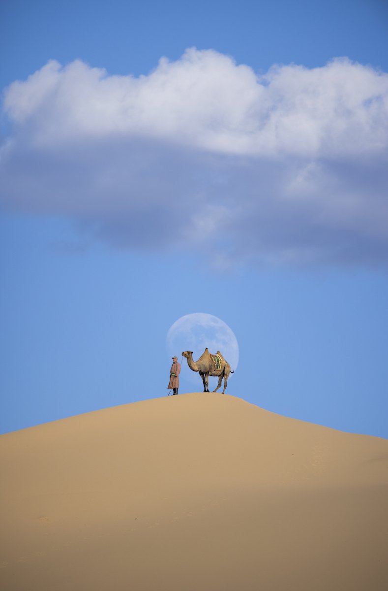
2. “The Camel Herder and the Supermoon”
Our time in the Gobi Desert coincided with the June super moon, also known as the Strawberry Moon. We arranged for camel handlers and their camels to join us for sunset and nighttime photo shoots. We came up with the concept of positioning one of the camel herders on a distant dune in order to make the most of the rising super moon. We were fortunate to have soft light and some low-hanging clouds that didn’t obscure the moon as it rose. It was definitely a magical moment to see all those elements align in front of our eyes.
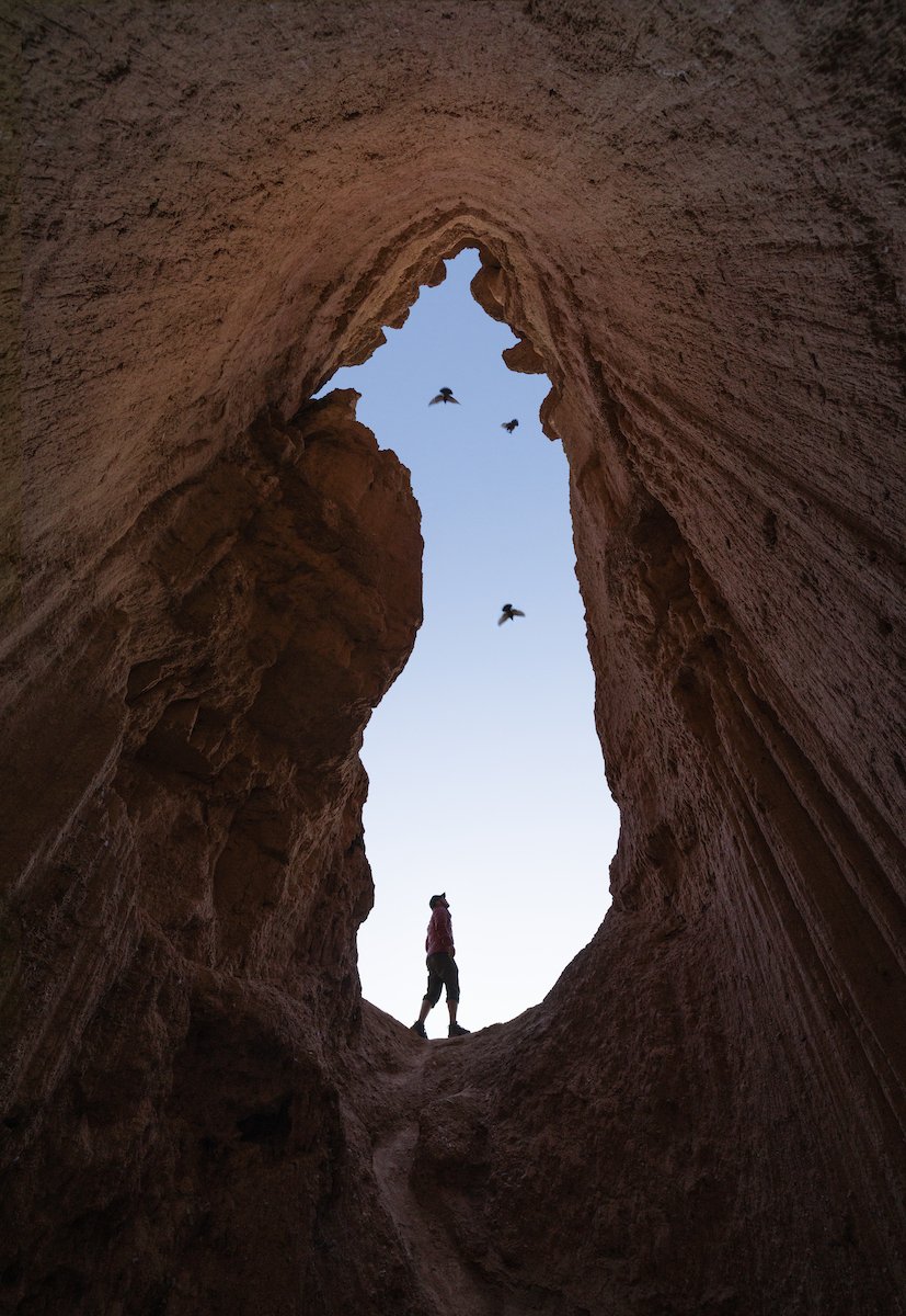
3. “The White Stupa”
This image is the result of childlike curiosity. The image was taken in an intriguing feature that I spotted from far away alongside trip co-leader Curtis Jones. When we investigated closely, the feature turned out to be a massive keyhole that we could drop into and shoot out of. I shot a few frames right away to take advantage of the alpenglow and by a stroke of luck, a few birds flew through the frame. To me, this image represents the importance of being curious in photography and, and following your nose and sticking your head and things.
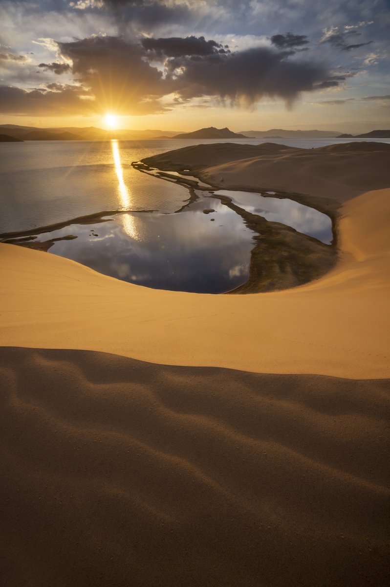
4. “Ulaagchiin Khar”
This was taken at Ulaagchiin Khar Lake in West Central Mongolia after the photography workshop came to a close. This was a place that took a lot of working and driving to get to. We didn’t have much time at this location so I made the most of it by shooting in the early morning. I shot the sunrise from the top of the biggest dune in a vast dune field that juts out into the middle of the turquoise lake. I started looking for interesting foregrounds as soon as I reached the top of the dune and found amazing ripples to work with. Those ripples became the leading lines in this classic landscape shot featuring beautiful rich light and some nice geometry.

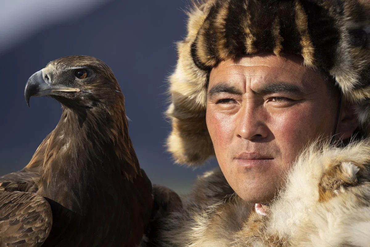
5. “Jenisbeck”
Last but not least, we have this tight portrait of eagle hunter Serik Jenisbek in the village of Sag Sai. We created this image at sunset in some phenomenal natural light. I must have shot thousands of images of Serik Jenisbek, both with his eagle and on his horse. This is one of my favourite shots of the lot because it has a candid feel and capturing the intimate connection between Jenisbek and his eagle was a very special moment.
Overall, this trip to the Gobi Desert and Western Mongolia was absolutely incredible. Mongolia is quickly becoming one of my favourite countries in the world, not just for the photography but for the people and the sense of isolation you experience when you’re there. I hope these images convey the natural beauty and variety that Mongolia has to offer.
View the collection of Mongolia images available as Limited Edition Prints!
Join OFFBEAT in Mongolia in 2024: sign up for our newsletter to stay in the loop about this trip.
Thank you to Mongolia Expeditions for being terrific hosts.

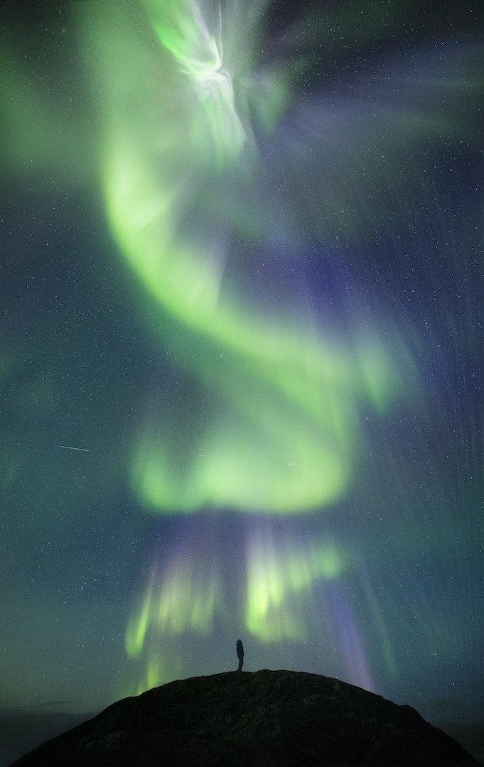
Greenland Grandeur: Ice, Water and Northern Lights
Earlier this year, I was fortunate to spend an entire month in Greenland, a place that feels like my second home. This trip, which marked my 6th visit to the island country known as Kalaallit Nunaat in Greenlandic and Grønland in Danish, involved leading two OFFBEAT photography workshops in familiar locations and working on a tourism photography project at a destination that was new to me. Despite revisiting several places, natural wonders such as ice, water, and northern lights made each experience unique.
Earlier this year, I was fortunate to spend an entire month in Greenland, a place that feels like my second home. This trip, which marked my 6th visit to the island country known as Kalaallit Nunaat in Greenlandic and Grønland in Danish, involved leading two OFFBEAT photography workshops in familiar locations and working on a tourism photography project at a destination that was new to me. Despite revisiting several places, natural wonders such as ice, water, and northern lights made each experience unique.
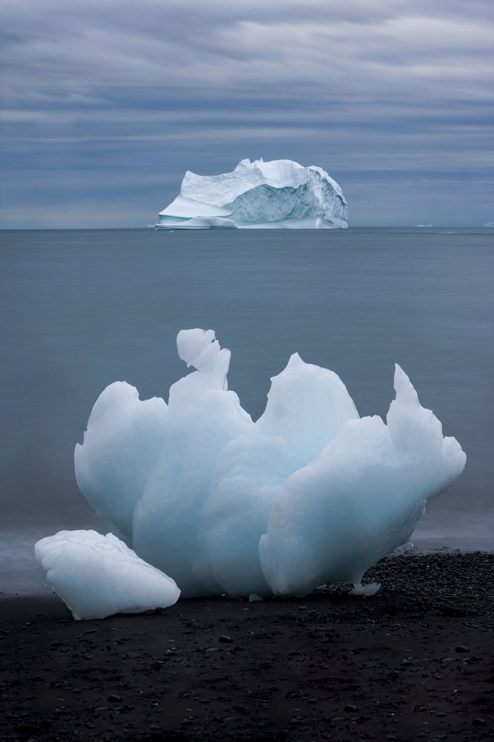
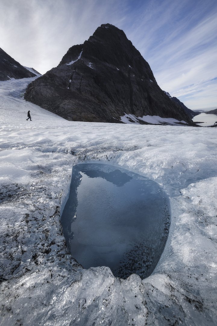
I arrived in Ilulissat for the first edition of the Greenland Grandeur workshop alongside fellow trip leaders Curtis Jones and Stephen DesRoches. We had each made numerous trips there and all agreed that we had never seen so much ice there before. Considering the recent launch of my Cryophilia project, which revolves around documenting disappearing glaciers and ice, I was excited for the photo possibilities. I was also thrilled for the participants who arrived a few days after we did.
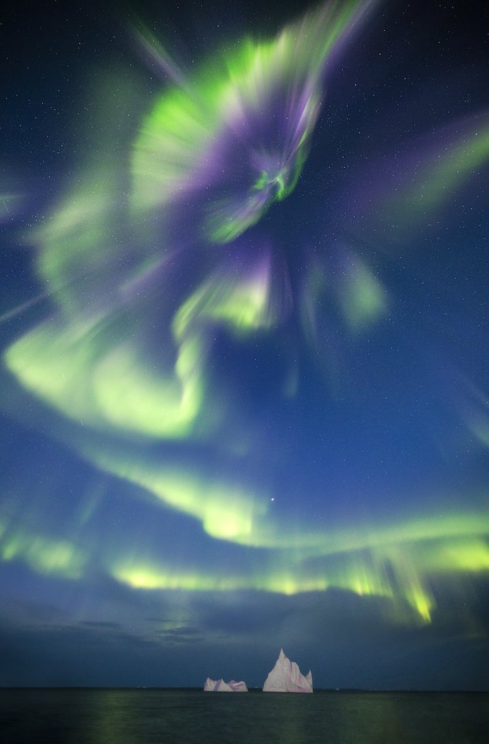
During the first half of the workshop, we focused our attention on the sea ice in the fjords of Ilulissat and were treated to an incredible aurora display. We then took a ferry to Disko Island, where we photographed black sand beaches and Kuannit, my favourite stretch of coastline in the world. Foul weather sent us back to Ilulissat early, but the consolation prize was documenting more incredible ice formations around Ilulissat.

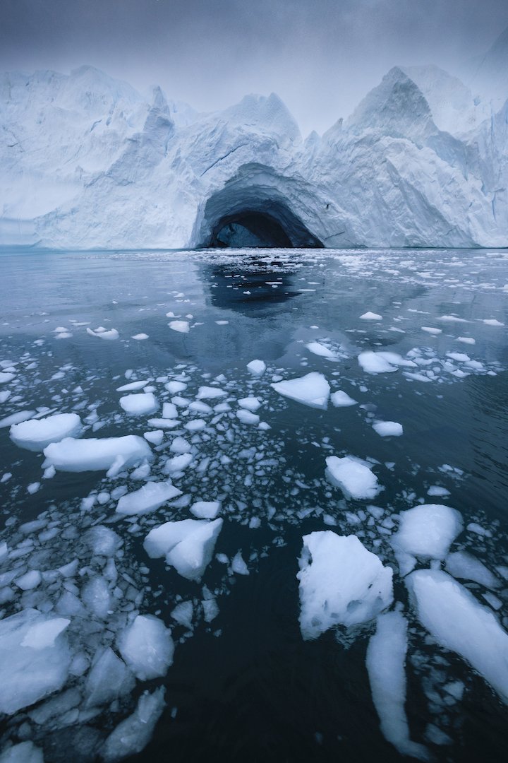
Gargantuan ice formations off the coast of Greenland.
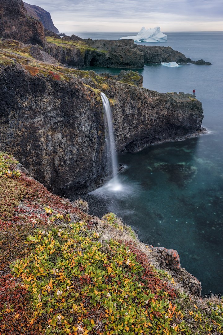
The second workshop brought lots of familiar faces to Greenland. Participants were treated to an incredible aurora display upon arrival, before the workshop had officially started. With a wide spectrum of colours filling the sky, it was possibly the best aurora display of the entire month. The workshop program mirrored the first and it mostly went according to plan; the only curveball was that during our stay on Disko Island, Greenland got the biggest rain event it’s seen in over 40 years.
We may have been damp but we kept our spirits high and continued getting out regardless of the downpour. When the weather does unexpected things, it also leads to unexpected photo ops. We witnessed some beautiful things including the area’s waterfalls flowing at ten times the volume and unusual chocolate-coloured water flowing onto the beach and into the iceberg-laden sea. We made the most of it before heading back to Ilulissat to wrap up the program.

A rare combination: chocolate-coloured waves and a black sand beach.
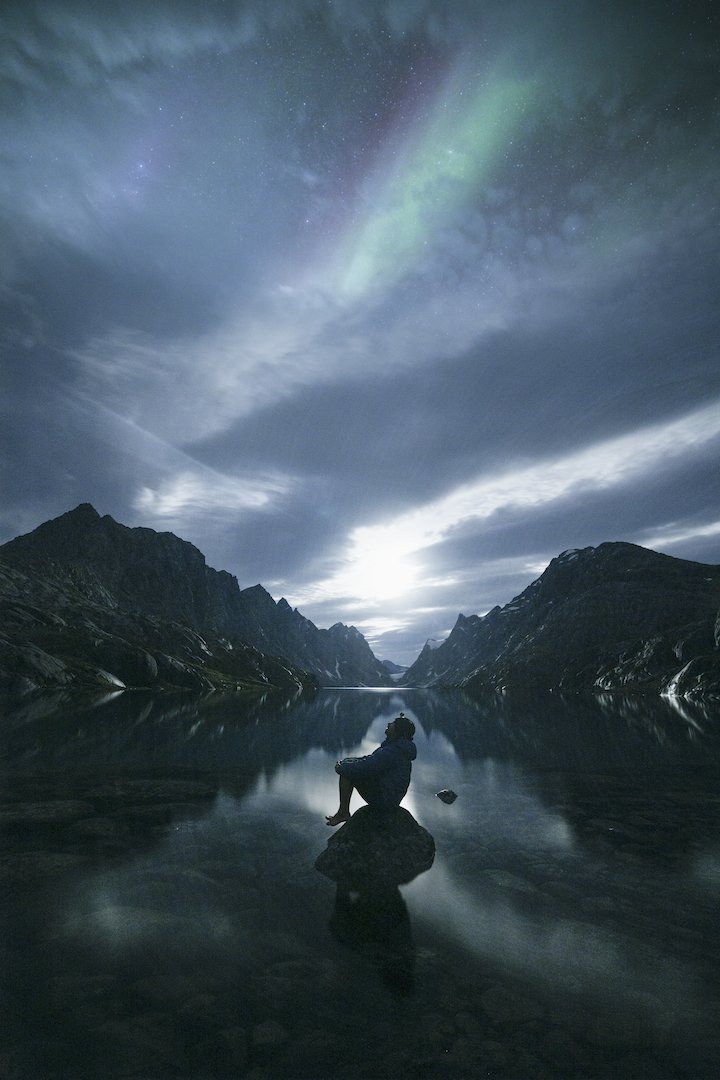
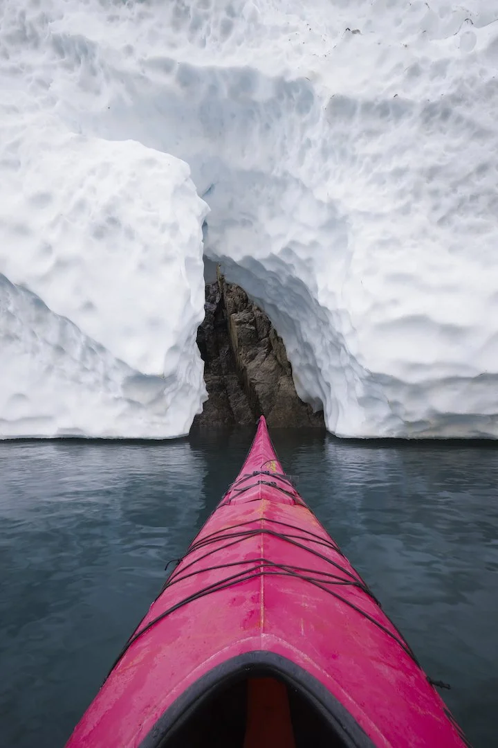
Curtis, Stephen and I stayed on for a few extra days. We called this period “play time” but we are actually heading to Maniitsoq in western Greenland on an assignment for Destination Arctic Circle and Visit Greenland. We were thrilled to explore a place that none of us had seen before, especially since the few photos of Maniitsoq we could find were oozing with potential. Although harsh weather caused travel delays that cut our play time in half, we decided to head to Maniitsoq anyway. We were greeted by Ole from Maniitsoq Adventure Tours who sailed us to Inussuit Tasersuat, a narrow lake flanked by steep mountain ranges known as “The Great Lake of Giants”.
The instant we laid eyes on Inussuit Tasersuat, we unanimously agreed it was one of the most beautiful places we had ever seen. I was so blown away by the possibilities, I didn’t know where to start. It was one of the most epic places I’d ever seen and I wanted to do it justice by conveying that ‘wow factor’. We got to work right away and shot the lake from a variety of angles in diverse conditions. We shot it by day and night, from land and underwater, with a drone and even from kayaks provided by Ole. We even witnessed the aurora shimmering high above the landscape, but for me, the highlight was doing a full traverse of the lake in a kayak on a calm morning surrounded by towering peaks, glaciers, and their reflections. Inussuit Tasersuat is one of the most naturally beautiful places I’ve ever come across and I hope I’ll be lucky enough to return there one day.

Inussuit Tasersuat, also known as “The Great Lake of Giants”.
Both workshops and our playtime unfolded in phenomenal landscapes. Photographs allow me to share the majesty of these scenes, but they don’t convey the meaningful conversations we shared with the locals we encountered. Considering that three quarters of Greenland is covered by the only permanent ice sheet that exists outside Antarctica, I asked locals like Ole and our boat drivers about the changes to the ice that they’ve witnessed in their lifetimes. They all told us that the glaciers are receding at an alarming and unprecedented rate. Hearing this underscored what a privilege it is to be able to see and document that ice before it disappears. I hope you enjoy these images, but most of all, I hope they spark your curiosity about our planet’s vanishing ice.


Behind the Image: Wonder Spire
I shot this self-portrait earlier this week during an overnight adventure into a rarely visited corner of Kootenay National Park. The traverse from the world-famous Lake O'Hara, in British Columbia, to the even more famous Moraine Lake, in Alberta is undertaken by a handful of parties every year. Here’s the story behind the image!

Wonder Spire by Paul Zizka.
I shot this self-portrait earlier this week during an overnight adventure into a rarely visited corner of Kootenay National Park. Fellow photographer Natalie Gillis and I had planned a traverse we'd both wanted to do for quite some time: the crossing from the world-famous Lake O'Hara, in British Columbia, to the even more famous Moraine Lake, in Alberta. This is a trip that is undertaken by a handful of parties every year and typically done in a long-ish day. Our own adventure would require a twist of sorts. For one, the two roads leading to the lakes were no longer in operation due to the tardy time of year and the incoming winter. Furthermore, halfway between the lakes, tucked between Opabin and Wenkchemna Passes, lies an improbable, spectacular tower called the Eagle's Eyrie. And we really wanted to photograph it at night, which would require lingering after dark and then making our way up and over the second of the passes at first light.
We started off by hiking 11km from the TransCanada Highway to Lake O'Hara. This was Nat's first-ever visit to the majestic lake. Although I'd been there many, many times before, it truly is a place that never gets old, and it was such a joy to introduce Nat to the area. We took a small detour by Lake Oesa and the Yukness Ledges to deepen Nat's appreciation of that part of Yoho National Park, and then we crossed the Opabin Plateau, cramponned up the Opabin Glacier, and descended scree into Kootenay National Park, beelining for the massive limestone tower that stands tall above the valley floor. The Eyrie is special in many ways: its sheer size, its isolation and its aesthetics among others. It even happens to have what looks to be a stone eagle perched on the top!
We were thrilled to finally have arrived at our main photographic subject and got to work right away, shooting the last remaining hues of the sunset. Later on, once we got the JetBoil going for a quick backcountry dinner, Nat noted that the moonlight had started to hit the surrounding peaks. A quick iPhone test shot confirmed the incredible potential for photography right there and then, and so I abandoned my Backpacker's Pantry lasagna and hurried over to a different side of the spire that would allow me to silhouette it against the moonlit walls of Curtis Peak. Immediately I was struck by the symmetry and decided to try to build an image that would showcase it, as well as the scale and grandeur of the spire. I moved my feet a little to centre the spire with respect to the background skyline and then waited until the shadow of Wenkchemna Pass would create a saddle of light behind the Eyrie. Once the timing got close, I proceeded to enter the frame, as I often do. I locked focus on the tower, set the camera to f/2.8, ISO 3200, 15 seconds, and put the intervalometer to work. Mother Nature took care of the rest. The sky turned out nicely with the moonlight giving it a blue cast, and the clouds racing past the peaks.
I hope you like the result. I'm hopeful this image will take me back to that night and location for many years to come, as it was truly a special moment in the Kootenay backcountry!
This image is available as a Limited Edition Print in a variety of sizes and formats.
Ecuador: Capturing Vanishing Ice on the Equator
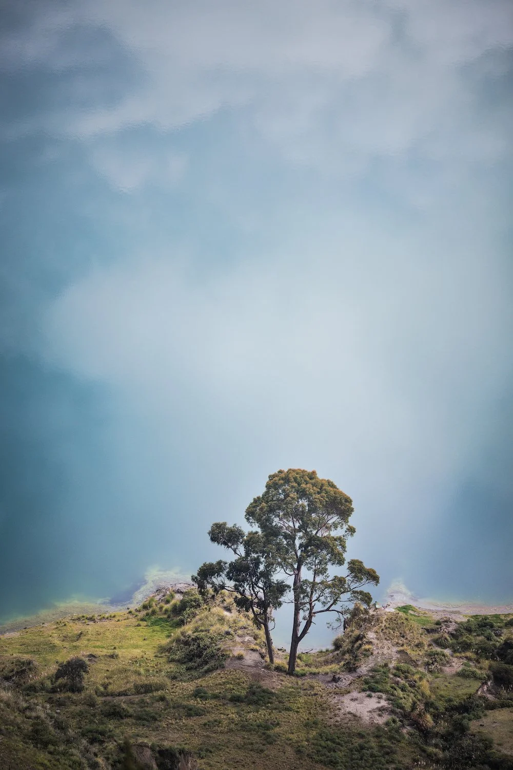
On a mission to document vanishing ice across the globe, I found myself in Ecuador back in February — a South American nation named for its position on the Equator. You may wonder why I’m chasing ice on the Equator, but Ecuador is home to Andean peaks towering up to 6,310 metres. It turns out that the country’s stratovolcanoes are home to a number of receding glaciers.
On a mission to document vanishing ice across the globe, I found myself in Ecuador back in February — a South American nation named for its position on the Equator. You may wonder why I’m chasing ice on the Equator, but Ecuador is home to Andean peaks towering up to 6,310 metres. It turns out that the country’s stratovolcanoes are home to a number of receding glaciers.
I arrived in Quito with a friend and fellow photographer, Kris Andres. An assault on all the senses, Quito was as colourful, bustling, and stimulating as I imagined. We hiked to the summit of Volcán Pichincha (4,800 m) to acclimatize for the higher elevations we planned to reach. Having spent time at elevation in Africa and Nepal, I acclimatized rather well.
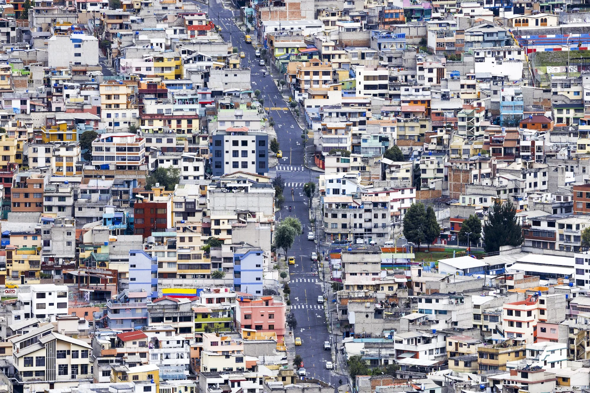
Colourful and bustling Quito. Photo by Paul Zizka.
Quito is surrounded by hills and highlands, which we were eager to explore. It wasn’t long before we were en route to our next objective: Volcá Illiniza Norte (5,126 m). We set off around midnight in light snow, guided by the light of our headlamps. Conditions were challenging due to the build-up of ice and rime from the previous day’s storm. We couldn’t see anything when we reached the summit but just as we were about to pack up, everything opened up. It was absolute magic and everything I could wish for as a photographer: brilliant side light, dynamic clouds, and Illiniza Sur (5,245 m) rising in the background. In terms of scenery and photography, that fifteen minutes was the highlight of the entire trip.
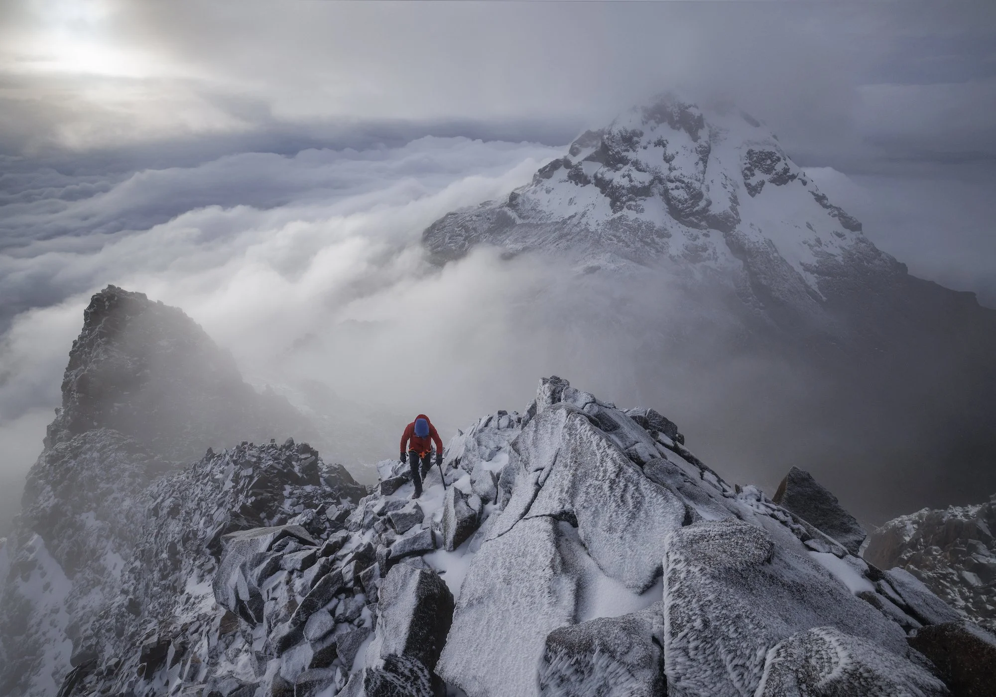
Clouds parting momentarily on the summit of Volcan Illiniza Norte. Photo by Paul Zizka.
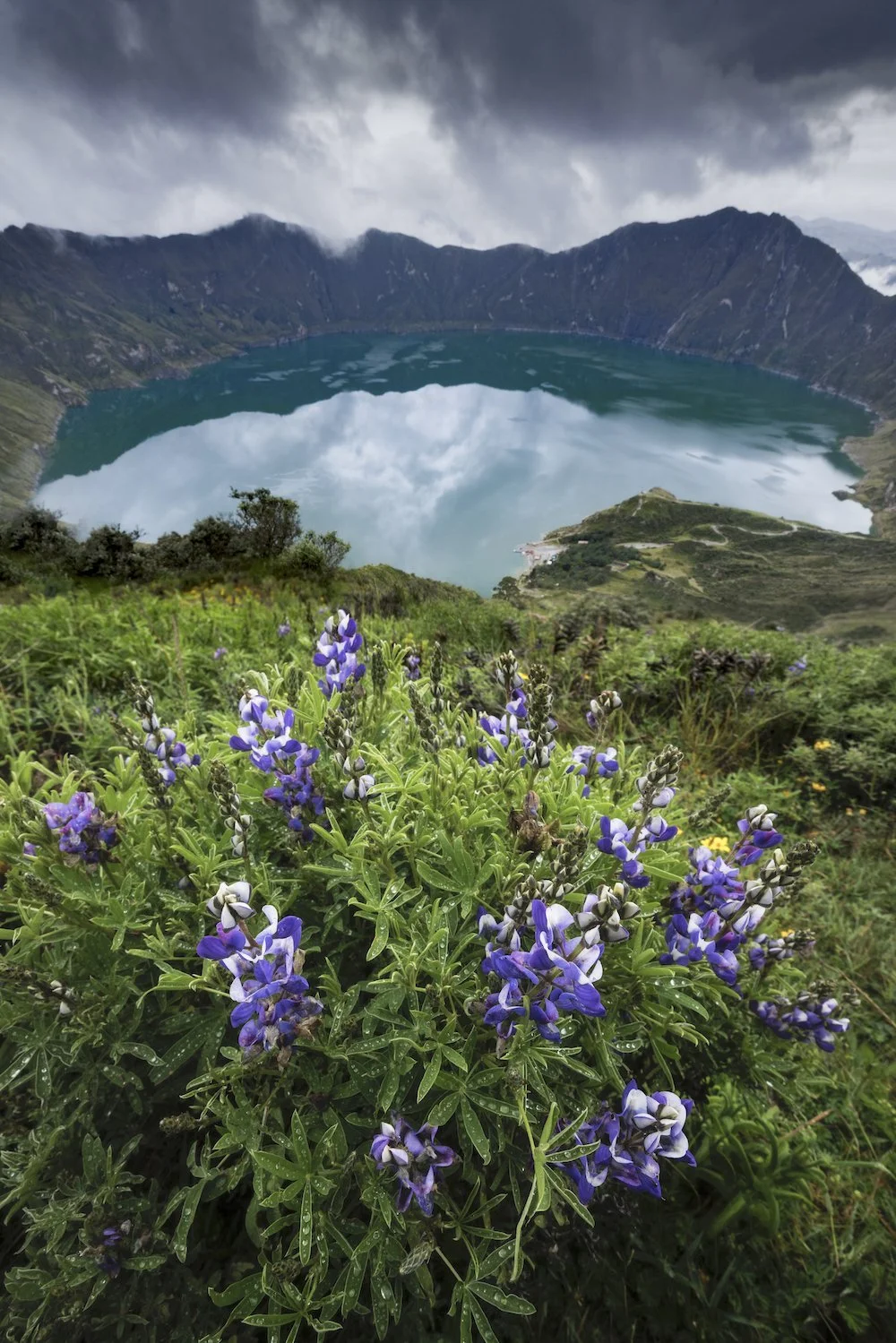
That’s not to say that the rest of our time in Ecuador wasn’t absolutely mind-blowing. Following Illiniza Norte, we hiked into the Jose Ribas refuge by circumventing the Quilotoa Crater. We spent half a day walking on the rim of a vast volcano, immersed in scenery that was unlike anything I’d ever seen before. Quilotoa is much older than the two previous volcanoes, geologically speaking. The landscape is also incredibly lush and vibrant. Traversing such different terrain was a refreshing intermission before our biggest climb.
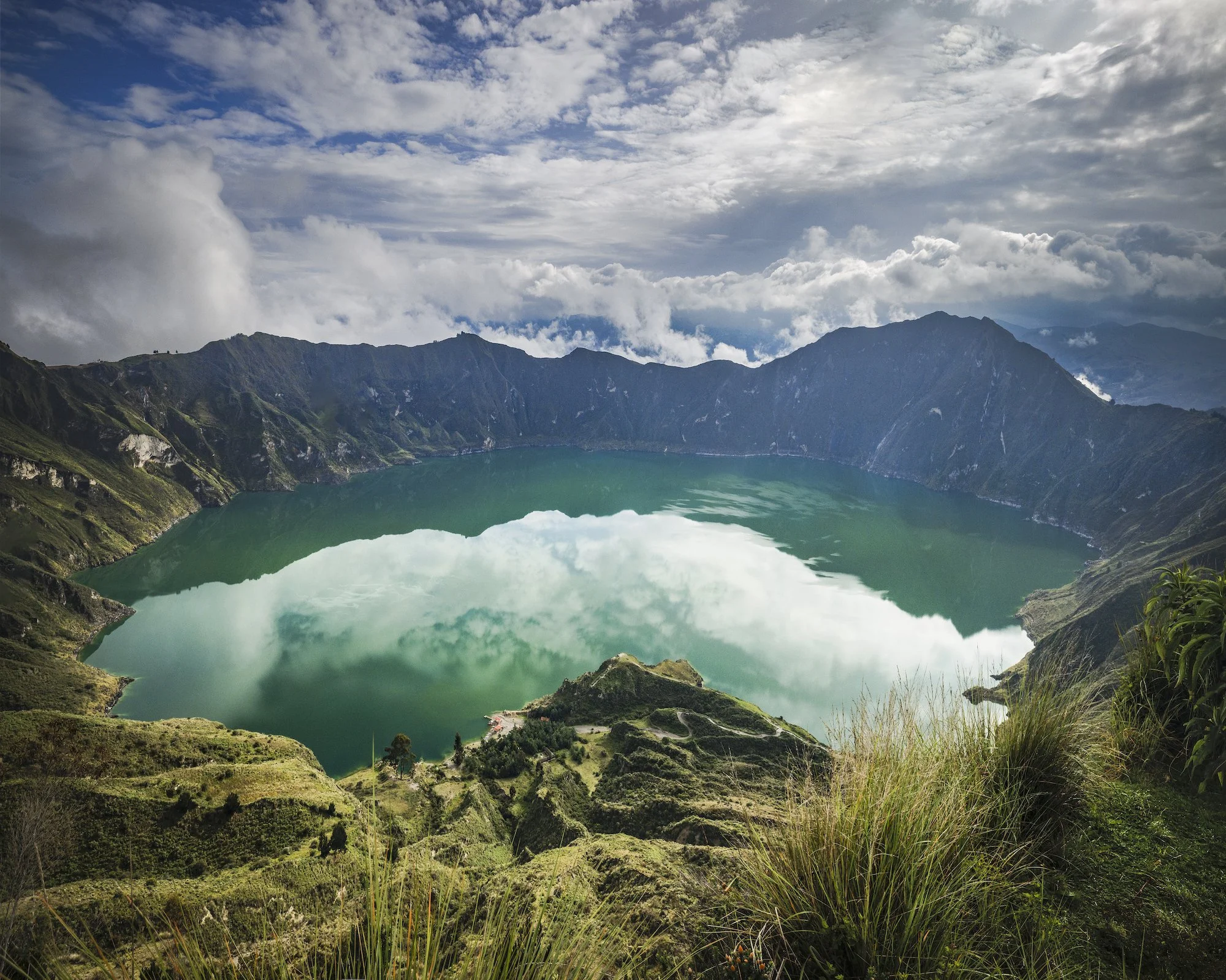
Quilotoa Crater. Photo by Paul Zizka.
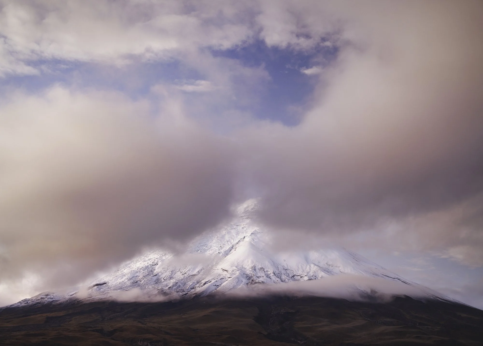
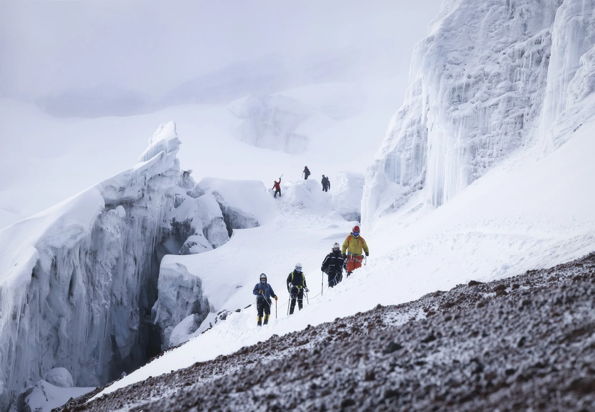
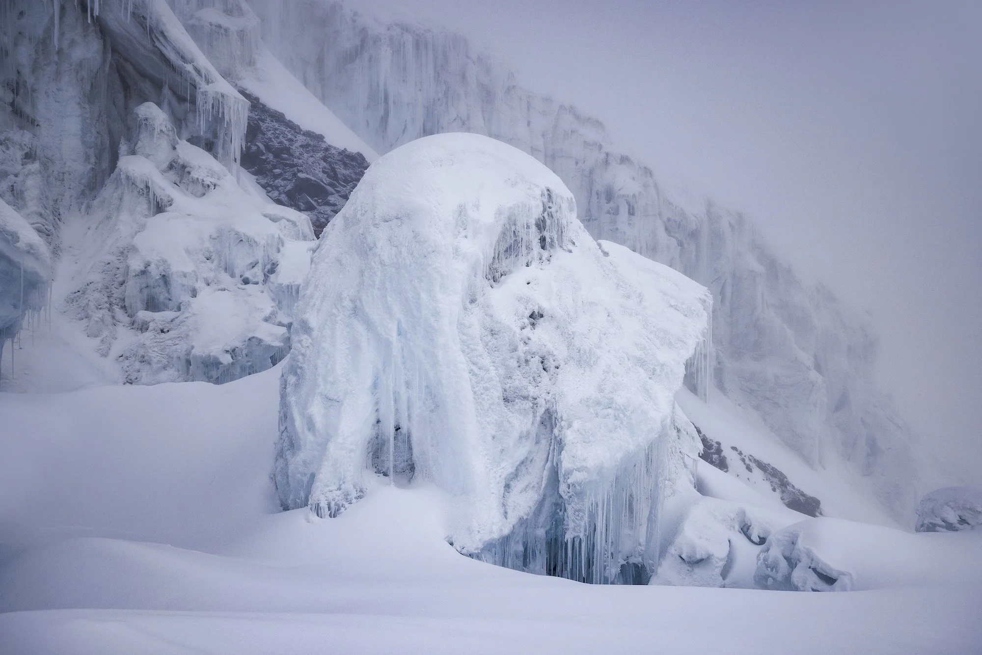
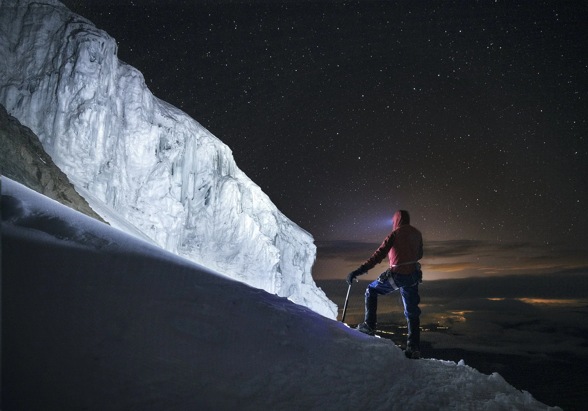
The pinnacle of our trip was Volcán Cotopaxi (5,897 m) located about 50 km south of Quito. We stayed at Tambo Paxi at the base of the volcano, got up to shoot the sunrise, then drove all the way up to a shelter that sits at an elevation of approximately 5000 metres. We got some rest but were up at 11 pm for a midnight start. With a new moon, we could only see as far ahead as our headlamps allowed. A billion stars glimmered overhead and Quito’s lights were visible in the distance. We wove our way through seracs towards the summit. Clouds rolled in halfway up, which was unfortunate for photos but added to the atmosphere.
We topped out on the edge of a giant summit crater. Eventually, other rope teams arrived at the summit of Cotopaxi. The clouds didn’t part until we were halfway down, revealing distant volcanoes and volcanic plains. The descent was magical and made for some great photo opportunities and some of my favourite images from the trip.
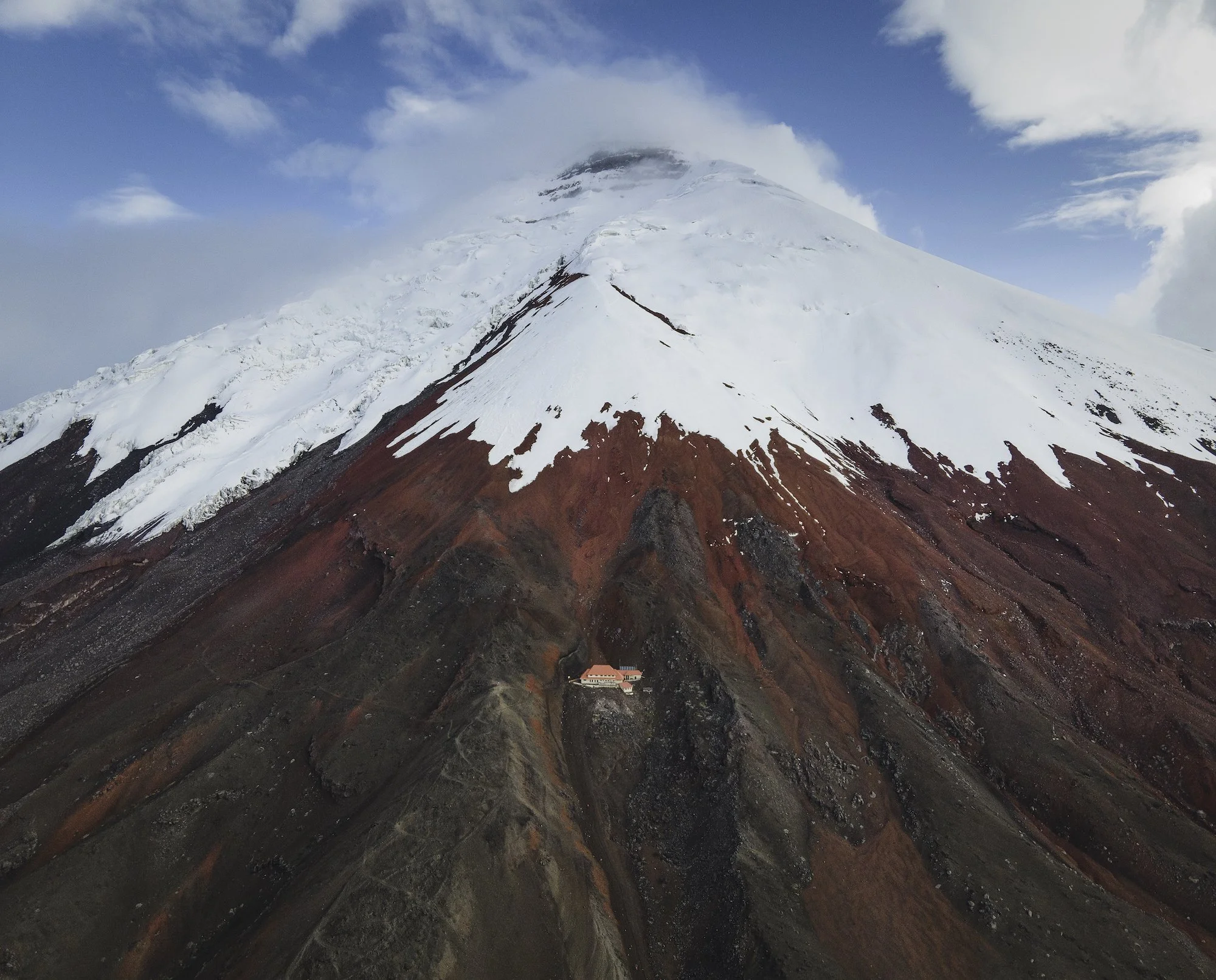
The Cotopaxi Refuge. Photo by Paul Zizka.
This trip to Ecuador was a wonderful opportunity for me to observe a new landscape, experience a new culture, and document rapidly changing glaciers that sit high up on the Equator. The trip came with its own challenges, like shooting in a highly dynamic environment that’s constantly changing. With volcanoes attracting and shedding weather quickly, I had to be on the ball to make the most of brief windows of opportunity. Overall, It was unbelievable to climb ice so close to the equator and gaze into distant coastal areas and jungles from a high altitude. The trip ultimately revealed that Ecuador is full of kind people and offers a ton of variety despite being such a small country. I certainly look forward to returning someday!
Weaving through seracs on our ascent of Cotopaxi. Photo by Paul Zizka.

Memories from Africa: Wildlife, Climbing and the Last Glaciers
A collection of my favourite images from a recent photography workshop and photo mission to capture the last ice in Botswana and Uganda.
After a long pause from leading workshops abroad, I was fortunate to embark on two trips in the latter half of 2021. The most recent was a journey to beautiful Botswana, a must-see for landscape and wildlife lovers alike. This particular adventure provided the best of both worlds; it began with an immersive OFFBEAT workshop experience and ended with a personal trip to document some of the only remaining ice on the African continent. Both resulted in memories I will cherish for a long time.
Breathless in Botswana
The workshop went marvellously well. We split our time between the Khwai Private Reserve of the Okavango Delta and Chobe National Park. We were fortunate to spot elephants, big cats, giraffes, hippos, baboons, and birds of many feathers. Since we could never predict which animals we would come across, each game drive and boat cruise provided a completely unique experience. Each of our participants went home with thousands of photographs of dozens of animals. For me, the most memorable encounters involved cheetahs, elephants, and lions bathing in magical African light.
One of Covid’s silver linings has been renewed appreciation. While I recognized the value of travel prior to the pandemic, it all felt a touch more special this time around. Whether gathering with old friends, meeting new faces, teaching again, drinking local coffee, or sitting quietly with a lion—it all seemed even more precious.
If you’ve never been to Botswana, you absolutely need to add it to your bucket list. Everything about this country, from its diverse landscapes and animals to its generous people, will leave you breathless.

A mother and baby elephant in Chobe National Park, Botswana. Photo by Paul Zizka Photography.


The Mountains of the Moon
After wrapping up the workshop, I embarked on a personal journey to find and photograph the last remnants of ice on the African continent. I chase ice because of its surreal beauty, its impact on the land and its people, and because it's so quickly disappearing. Chasing ice in Africa led me deep into the Rwenzori Mountains, located on the border between Botswana and Uganda. They are also known as the Mountains of the Moon.
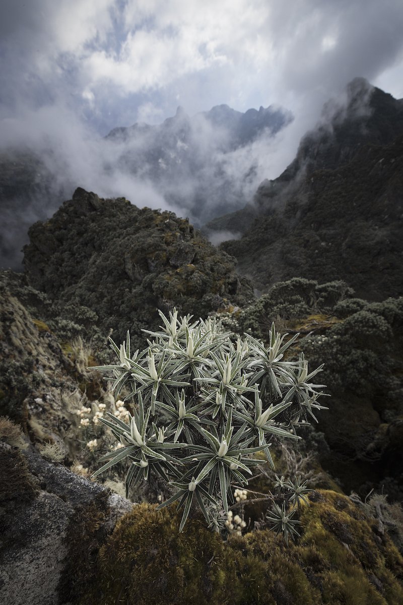
Much of the multi-day trek was spent following our local guides through an otherworldly landscape of tropical plants and ancient rock shrouded by mist and rain. The highlight of the trip was the surreal summit day high on Mount Stanley. There I was in an extremely remote area, at one of the last remaining glaciers in Africa. I was sitting at 5,109 m above sea level in -20C temperatures and zero visibility with one butt cheek in Congo and the other in Uganda. I was there, in that quiet and sacred place, as news from the outside world trickled in: the Omicron variant was beginning to shut down travel to many African nations. It was a bizarre experience and an emotional rollercoaster.
You may think of glaciers when you think of Africa, but ice does exist there—for the time being. The now-tiny glaciers of that region have existed for a long, long time. They have had a massive impact on the land and the locals throughout history. They carved the valleys into what you see today and they provided water for life to fill those valleys. I chase ice because of its surreal beauty, its impact on the land and its people, and because it's so quickly disappearing. Embarking on this trip to see those glaciers in their terminal state was deeply moving and well-worth documenting for me.

The Rwenzori (also spelled Ruwenzori or Rwenjura) is a mountain range in eastern equatorial Africa, on the border between Uganda and the Congo. Photo by Paul Zizka Photography.


Guides on the summit of Mount Stanley (5,109 m). Photo by Paul Zizka Photography.

One of the many waterfalls we encountered during the trek. Photo by Paul Zizka Photography.

Behind the Image: The "What If" Time
Perhaps the two rules you hear the most in landscape photography are “the rule of thirds” and “the importance of moving your feet.” The first one I think gets way too much attention, but the latter cannot be emphasized enough. This image is a prime example.
Perhaps the two rules you hear the most in landscape photography are “the rule of thirds” and “the importance of moving your feet.” The first one I think gets way too much attention, but the latter cannot be emphasized enough.
This image is a prime example.

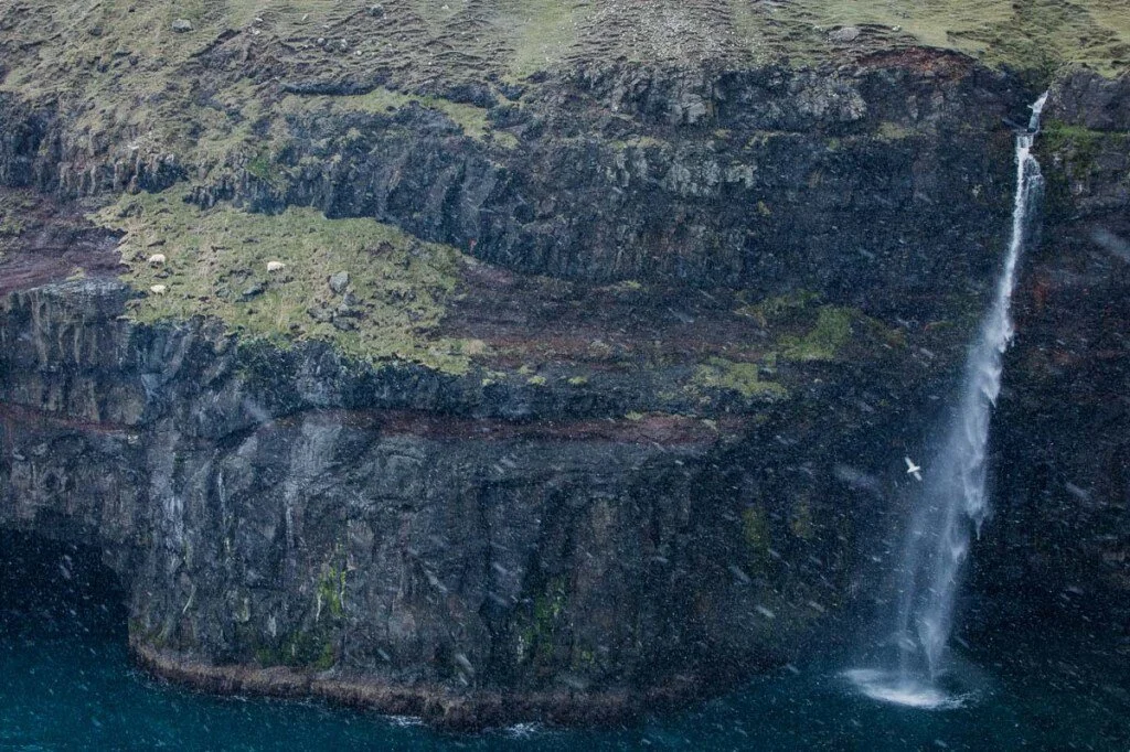
Kalsoy, Faroe Island. Photo by Paul Zizka.
I shot this in the Faroe Islands on Kalsoy (a particularly epic corner of the archipelago). My OFFBEAT colleague Dave Brosha and I spent a considerable amount of time there, starting off with the compositions that were obvious to us immediately upon arrival. It's a phenomenal place, quite overwhelming, and we were engrossed for a while. And I think we both created a few solid images. But, for me, the real magic happened at the tail end of our visit there, during what I call the "what if" time.
That "what if" time is often when I create my best images. At that point, I (hopefully) have at least one more "traditional" image I'm happy with and I start to operate with more freedom, with a more open mind, more experimentally. And, usually, that means covering some ground. I try to always make time to walk, scramble and downclimb so I can get a different perspective on the place. Often it leads to nothing (but, hey, I get some exercise out of it and it satisfies my curiosity). But occasionally it'll open a photo op that completely takes me by surprise. It's often hard to predict how elements will line up once you've changed your point of view. You can guess but you never really know for sure until you've put in the work.
That day, it paid off. I left before Dave and wandered over to a nearby exposed ridge. When I turned back towards the area where we had been shooting for a couple of hours, a phenomenal scene took shape. A dip in the ridge aligned perfectly with some of the world's highest sea cliffs. Birds were swirling around and waves were crashing hard. There was even a high waterfall and some sea stacks to appreciate in the background. It became obvious that by compressing all that with a telephoto lens, and adding the human element, there was a strong image to be made. I ran back to where Dave was to get the 100-400 lens, had a chat with Dave, and then returned to my perch.
Dave walked the ridge a few times and in one of the shots everything ended up where it needed to be. The birds had good positioning and Dave had a stance that looked natural. I could have gone with a static pose but more and more I find dynamic modelling looks less forced.
I hope that encourages some of you to allow that extra five-minute period of exploration and exercise when you head out on your next photo excursion!
OFFBEAT is heading back to the Faroe Island for an unforgettable photography workshop, October 4-9, 2021! Find information and registration details here.
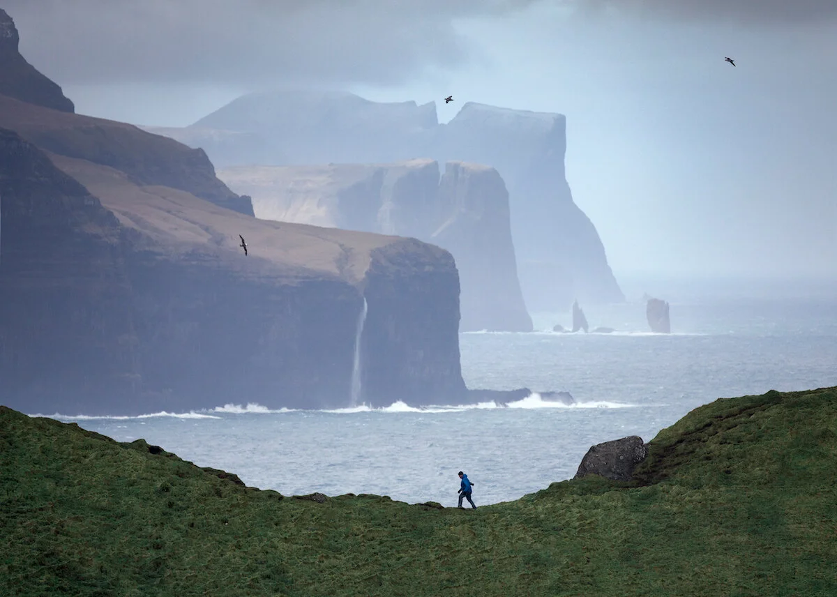
Photo Journey Through the Faroe Islands
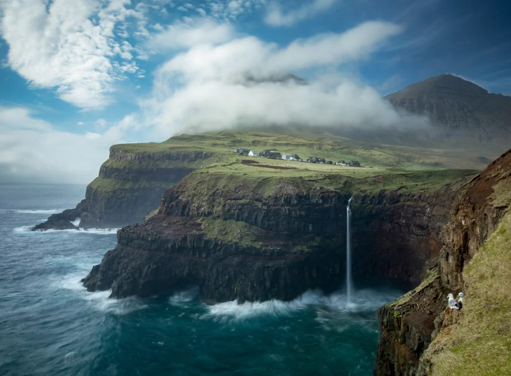
The Faroe Islands are a part of the majestic Kingdom of Denmark and located halfway between Iceland and Scotland in the North Atlantic Ocean. Endlessly rugged and beautiful, they are a prime location for landscape photography.
The Faroe Islands are a part of the majestic Kingdom of Denmark and located halfway between Iceland and Scotland in the North Atlantic Ocean. Endlessly rugged and beautiful, they are a prime location for landscape photography. In fact, OFFBEAT is headed back next fall for our ever-popular FAR OUT FAROES workshop!
It's one of my personal favourite places to shoot. Enjoy this compilation from this wild corner of the world!

Self-portrait at Slaettaratindur. Paul Zizka Photography.
Gasadalur locals, Vágar. Photo by Paul Zizka Photography.
The Faroe Islands are comprised of 18 rocky islands, which are linked together via road tunnels, ferries, causeways and bridges. Many hikers, photographers, and bird-watchers are drawn to the picturesque fjords, mountains, and steep coastal cliffs that thousands of seabirds call home.


Long exposure self-portrait on a stunning day on Slaettaratindur, Eysturoy. Photo by Paul Zizka Photography.


According to the stories passed down by generations, the first known settlers were Irish monks in the sixth century. However, evidence has shown that these islands were first inhabited as far back as the year 300 AD.

Faroese paintbrush. Gjogv cliffs. Photo by Paul Zizka Photography.

The incredibly colourful seacaves of Eysturoy. Photo by Paul Zizka Photography.

Snow and sunshine atop Slaettaratindur, highest peak in the Faroe Islands.
Photo by Paul Zizka Photography.
The name Faroe Islands first appeared as Faereyjar, which translates to “Sheep Islands.” This was the name in the ninth century, given by the Viking-age settlers from Norway and presumably the reason for their national symbol: a ram.
Hardy sheep at Mulafossur, Vagar. Photo by Paul Zizka Photography.

Vestmanna cliffs, Streymoy. Photo by Paul Zizka Photography


Self-portrait, southern Vágar. Photo by Paul Zizka Photography.
This mysterious archipelago is the spot for one of our upcoming workshops with OFFBEAT Photography! Click the image below for more information or to sign up!


The Wilder Side of Malta: Gozo
I had the chance to visit Malta with my family back in December and take in its wild coastlines, dramatic rock structures, and rugged seascapes. We also toured the old city of Valletta, which was a sight to behold, but I did not take out the camera much during that portion. Naturally, I’m drawn to the sea and landscapes, and here is the best I shot while in Malta. In fact, all of these images were taken on the Maltese island of Gozo.
The Republic of Malta is a country that defies description. Its history is as multi-layered and complex as its towering cliffs that hang over the sea. Located 80 km south of Italy and 333 km north of Libya, smack in the middle of the Mediterranean, Malta has been used as a naval base for centuries. It’s culture today possesses remnants of all those that came before, from the Phoenicians and Carthaginians to Romans and Greeks, Arabs and Normans, French and British. Remarkably, the habitation of the island goes back to 5900 BC and some of the oldest man-made structures on the planet can still be found there.
I had the chance to visit Malta with my family back in December and take in its wild coastlines, dramatic rock structures, and rugged seascapes. We also toured the old city of Valletta, which was a sight to behold, but I did not take out the camera much during that portion. Naturally, I’m drawn to the sea and landscapes, and here is the best I shot while in Malta. In fact, all of these images were taken on the Maltese island of Gozo.
All of these images are available as Limited Edition Prints in a variety of sizes and formats, as well as stock image licensing.

Dwejra Bay. Photo by Paul Zizka.

Dwejra Bay. Photo by Paul Zizka.

Wied Il-Mielaħ. Photo by Paul Zizka Photography.

Xlendi Bay. Photo by Paul Zizka Photography.

Xlendi Bay. Photo by Paul Zizka Photography.

Xlendi Bay. Photo by Paul Zizka Photography.

Sanap Cliffs. Photo by Paul Zizka Photography.

The Inland Sea at Dwejra Bay. Photo by Paul Zizka Photography.

Xlendi Bay. Photo by Paul Zizka Photography.

The Inland Sea at Dwejra Bay. Photo by Paul Zizka Photography.